IMAGES TAKEN NEAR TO
The Rowans, SHREWSBURY, SY4 1EF
Introduction
This page details the photographs taken nearby to The Rowans, SY4 1EF by members of the Geograph project.
The Geograph project started in 2005 with the aim of publishing, organising and preserving representative images for every square kilometre of Great Britain, Ireland and the Isle of Man.

There are currently over 7.5m images from over14,400 individuals and you can help contribute to the project by visiting https://www.geograph.org.uk
Image Map
Images are licensed for reuse under creativecommons.org/licenses/by-sa/2.0
Notes
- Clicking on the map will re-center to the selected point.
- The higher the marker number, the further away the image location is from the centre of the postcode.
Image Listing (6 Images Found)
Images are licensed for reuse under creativecommons.org/licenses/by-sa/2.0
Image
Details
Distance
1
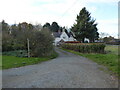
Approaching Mytton
Seeking the footpath ahead.
Image: © Jeremy Bolwell
Taken: 24 Nov 2021
0.01 miles
2
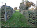
Footpath at Mytton
The footpath ahead has been re-routed to the field edge to avoid horses or ponies I think.
Image: © Jeremy Bolwell
Taken: 24 Nov 2021
0.05 miles
3
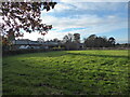
View towards Mytton Hall
Nice scene; a country house, a barn being re-roofed (I think) and a nice little village on a fine and sunny November afternoon.
Image: © Jeremy Bolwell
Taken: 24 Nov 2021
0.10 miles
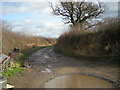
5
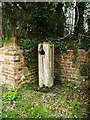
Old road-side pump
An old pump by the side of the lane at Mytton House. Mytton, north of Montford Bridge, near Shrewsbury, Shropshire
Image: © Keith Havercroft
Taken: 18 Mar 2006
0.19 miles
6
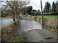
Whoops! Don't think I'll risk that - River Perry in flood (Jan' 2008)
Image: © Row17
Taken: 21 Jan 2008
0.24 miles