IMAGES TAKEN NEAR TO
Hopton, Nesscliffe, SHREWSBURY, SY4 1DJ
Introduction
This page details the photographs taken nearby to SY4 1DJ by members of the Geograph project.
The Geograph project started in 2005 with the aim of publishing, organising and preserving representative images for every square kilometre of Great Britain, Ireland and the Isle of Man.

There are currently over 7.5m images from over14,400 individuals and you can help contribute to the project by visiting https://www.geograph.org.uk
Image Map
Images are licensed for reuse under creativecommons.org/licenses/by-sa/2.0
Notes
- Clicking on the map will re-center to the selected point.
- The higher the marker number, the further away the image location is from the centre of the postcode.
Image Listing (11 Images Found)
Images are licensed for reuse under creativecommons.org/licenses/by-sa/2.0
Image
Details
Distance
1
Shropshire Way at Hopton, north of Nesscliffe
What footpath?
Image: © Andrew Shannon
Taken: 28 Jun 2023
0.07 miles
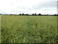
2
The Shropshire Way at Hopton, north of Nesscliffe
The footpath is totally impassable across this field. Also no field margin to enable the walker to negotiate the field. A shame that there no access is provided by the farmer for the walker on the legitimate Shropshire Way footpath. We need agricultural production, but also need legal access to the rapidly diminishing accessible countryside.
Image: © Andrew Shannon
Taken: 28 Jun 2023
0.09 miles
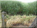
3
Path across arable field by Hopton Farm, Nesscliffe
Faint footpath showing today, but last time I was here on 28 June 2023 this field was impassable with a head high crop of oil seed rape. Easier walking today, but will not be so in a few weeks’ time.
Image: © Andrew Shannon
Taken: 30 Aug 2023
0.09 miles
4
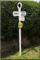
Old Direction Sign - Signpost in Hopton, South Shropshire
Annulus finial - 3 arms; Shropshire CC modern halo by the UC road, in parish of Hopton (South Shropshire District), Hopton.
Surveyed
Milestone Society National ID: SA_SJ3820.
Image: © Milestone Society
Taken: Unknown
0.10 miles
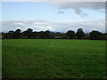
5

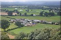
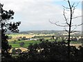
Startlewood Farm
Great view of this farm from the top of The Cliffe, not eligable as a Geograph as it was taken outside the square.
Image: © John Haynes
Taken: 30 Aug 2007
0.11 miles
7
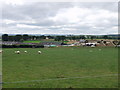
Startlewood Farm
A large range of traditional and modern buildings on this mixed farm.
Image: © John Haynes
Taken: 30 Aug 2007
0.14 miles
8
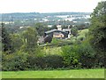
Hopton Farm
From the footpath onto Nesscliffe Hill.
Image: © Penny Mayes
Taken: 15 Sep 2009
0.17 miles
9
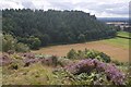
Hopton Hill
View of the middle woodland at Nesscliffe from The Cliffe to the north.
Image: © Richard Webb
Taken: 31 Jul 2016
0.20 miles
10
Mount Pleasant viewed from Nesscliffe Hill
Image: © Penny Mayes
Taken: 15 Sep 2009
0.24 miles