IMAGES TAKEN NEAR TO
Melverley Road, SHREWSBURY, SY4 1BU
Introduction
This page details the photographs taken nearby to Melverley Road, SY4 1BU by members of the Geograph project.
The Geograph project started in 2005 with the aim of publishing, organising and preserving representative images for every square kilometre of Great Britain, Ireland and the Isle of Man.

There are currently over 7.5m images from over14,400 individuals and you can help contribute to the project by visiting https://www.geograph.org.uk
Image Map
Images are licensed for reuse under creativecommons.org/licenses/by-sa/2.0
Notes
- Clicking on the map will re-center to the selected point.
- The higher the marker number, the further away the image location is from the centre of the postcode.
Image Listing (7 Images Found)
Images are licensed for reuse under creativecommons.org/licenses/by-sa/2.0
Image
Details
Distance
1
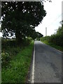
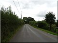
Minor road between Nesscliffe and Melverley
Long straight road - a quick journey in a car, but a longish slog on foot.
Image: © Andrew Shannon
Taken: 30 Aug 2023
0.17 miles
2
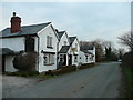
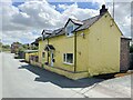
The Grove Inn, Pentre
Village pub on the village street.
Image: © Jonathan Billinger
Taken: 3 Jan 2008
0.17 miles
6
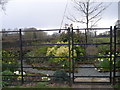
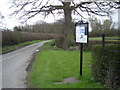
National Cycle Route 81 leaving Pentre
Towards Wilcott.
Image: © JThomas
Taken: 4 Sep 2024
0.21 miles