IMAGES TAKEN NEAR TO
The Orchard, Montford Lane, SHREWSBURY, SY4 1BQ
Introduction
This page details the photographs taken nearby to The Orchard, Montford Lane, SY4 1BQ by members of the Geograph project.
The Geograph project started in 2005 with the aim of publishing, organising and preserving representative images for every square kilometre of Great Britain, Ireland and the Isle of Man.

There are currently over 7.5m images from over14,400 individuals and you can help contribute to the project by visiting https://www.geograph.org.uk
Image Map
Images are licensed for reuse under creativecommons.org/licenses/by-sa/2.0
Notes
- Clicking on the map will re-center to the selected point.
- The higher the marker number, the further away the image location is from the centre of the postcode.
Image Listing (31 Images Found)
Images are licensed for reuse under creativecommons.org/licenses/by-sa/2.0
Image
Details
Distance
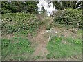
3
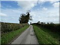
On part of the Severn Way near Shrawardine
Nice walking.
Image: © Jeremy Bolwell
Taken: 22 Mar 2023
0.07 miles
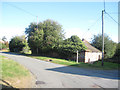
5
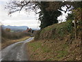
Road along which the Severn and Shropshire Ways pass through Shrawardine
Looking westward.
Image: © Peter Wood
Taken: 7 Dec 2016
0.08 miles
6
On part of the Severn Way near Shrawardine
A trig point and a waymarker post.
Image: © Jeremy Bolwell
Taken: 22 Mar 2023
0.08 miles
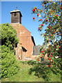
7

Remains of Shrawardine Castle
This castle was built in the mid 12th century, see http://www.castlewales.com/shraw.html and destroyed in the 17th century. Some of its stones were used to repair Shrewsbury Castle.
To be honest, there is not a lot to see now, although my photo does not show its fullest extent. For example, you can clearly see archways in the stonework when you're there.
Image: © Peter Craine
Taken: 10 Jun 2007
0.09 miles
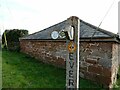
8
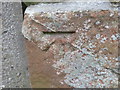
Ordnance Survey Cut Mark
This can be found on the roadside boundary wall of St Mary's Church in Shrawardine.
For more detail see : http://www.bench-marks.org.uk/bm81104
Image: © Peter Wood
Taken: 7 Dec 2016
0.09 miles
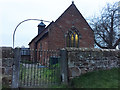
9
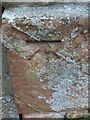
OS Cut Mark: Shrawardine, St Mary's Church
CUT MARK: WALL 0.9M S PRODN S FACE CH SW SIDE RD (ODN 87.7865m, AGL 0.5m).
Image: © thejackrustles
Taken: 24 Nov 2018
0.09 miles
10
Shrawardine, St Mary's Church
Cut mark also showing on roadside wall
Image: © thejackrustles
Taken: 24 Nov 2018
0.09 miles