IMAGES TAKEN NEAR TO
Shrawardine, SHREWSBURY, SY4 1AN
Introduction
This page details the photographs taken nearby to SY4 1AN by members of the Geograph project.
The Geograph project started in 2005 with the aim of publishing, organising and preserving representative images for every square kilometre of Great Britain, Ireland and the Isle of Man.

There are currently over 7.5m images from over14,400 individuals and you can help contribute to the project by visiting https://www.geograph.org.uk
Image Map
Images are licensed for reuse under creativecommons.org/licenses/by-sa/2.0
Notes
- Clicking on the map will re-center to the selected point.
- The higher the marker number, the further away the image location is from the centre of the postcode.
Image Listing (8 Images Found)
Images are licensed for reuse under creativecommons.org/licenses/by-sa/2.0
Image
Details
Distance
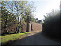
1
New track to equestrian business
Not on the latest OS mapping, but none-the-less a rural enterprise on land bordering the army training grounds.
Image: © Jonathan Billinger
Taken: 3 Jan 2008
0.11 miles
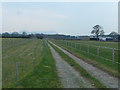
4
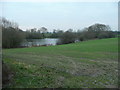
Folly Pool in mid-winter
Compare and contrast the same view in mid-summer; Image
Image: © Jonathan Billinger
Taken: 3 Jan 2008
0.17 miles
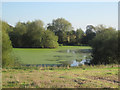
5
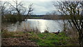
Folly Pool
Late afternoon and a pheasant surveys his territory.
Image: © Jonathan Billinger
Taken: 3 Mar 2016
0.17 miles
6
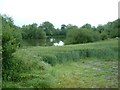
Folly Pool
The pool is just off the Severn Way footpath as it passes from Wilcott to Shrawardine
Image: © Tony Thomas
Taken: 18 Jun 2007
0.17 miles
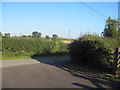
7
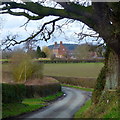
A glimpse of Folly Farm
Framed by the shape of a fine old oak tree by the lane next to Folly Pool.
Image: © Jonathan Billinger
Taken: 3 Mar 2016
0.22 miles