IMAGES TAKEN NEAR TO
Port Hill Road, SHREWSBURY, SY3 8SA
Introduction
This page details the photographs taken nearby to Port Hill Road, SY3 8SA by members of the Geograph project.
The Geograph project started in 2005 with the aim of publishing, organising and preserving representative images for every square kilometre of Great Britain, Ireland and the Isle of Man.

There are currently over 7.5m images from over14,400 individuals and you can help contribute to the project by visiting https://www.geograph.org.uk
Image Map
Images are licensed for reuse under creativecommons.org/licenses/by-sa/2.0
Notes
- Clicking on the map will re-center to the selected point.
- The higher the marker number, the further away the image location is from the centre of the postcode.
Image Listing (38 Images Found)
Images are licensed for reuse under creativecommons.org/licenses/by-sa/2.0
Image
Details
Distance
1
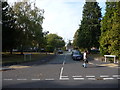
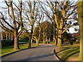
Woodbank Drive, Porthill, Shrewsbury
A small, select and secluded close or cul-de-sac rather than a drive but what's in a name?
Image: © Jeremy Bolwell
Taken: 30 Sep 2011
0.10 miles
2
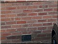
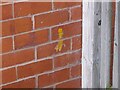
Ordnance Survey Cut Mark
This OS cut mark can be found on No48 Woodfield Road. It marks a point 76.815m above mean sea level.
Image: © Adrian Dust
Taken: 3 Jul 2023
0.12 miles
3
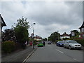
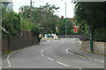
Part of Woodfield Road, Copthorne, Shrewsbury
Near the shop and mini roundabout.
Image: © Jeremy Bolwell
Taken: 11 Jun 2020
0.13 miles
4
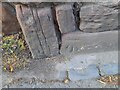
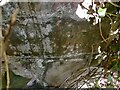
Ordnance Survey Cut Mark
This OS cut mark can be found on the wall SE side of Porthill Road. It marks a point 76.283m above mean sea level.
Image: © Adrian Dust
Taken: 3 Jul 2023
0.15 miles
5
Footpath through Shrewsbury School grounds
Taken on a sunny day in January
Image: © Marion Haworth
Taken: 27 Jan 2008
0.16 miles
7
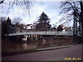
Suspension Bridge
This is a foot bridge crossing the River Severn
Image: © Mr M Evison
Taken: 2 Jan 2006
0.18 miles
8
Ordnance Survey Cut Mark
This OS cut mark can be found on No1 Woodfield Avenue. It marks a point 78.315m above mean sea level.
Image: © Adrian Dust
Taken: 3 Jul 2023
0.18 miles
9
Ordnance Survey Cut Mark
This OS cut mark can be found on the wall NW side of the path. It marks a point 59.780m above mean sea level.
Image: © Adrian Dust
Taken: 4 Jul 2023
0.19 miles
10
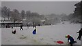
Winter fun by the River Severn
Sledging and snowman building in a brief cold snap in December 2017.
Image: © Andrew Abbott
Taken: 10 Dec 2017
0.19 miles