IMAGES TAKEN NEAR TO
Copthorne Drive, SHREWSBURY, SY3 8RX
Introduction
This page details the photographs taken nearby to Copthorne Drive, SY3 8RX by members of the Geograph project.
The Geograph project started in 2005 with the aim of publishing, organising and preserving representative images for every square kilometre of Great Britain, Ireland and the Isle of Man.

There are currently over 7.5m images from over14,400 individuals and you can help contribute to the project by visiting https://www.geograph.org.uk
Image Map
Images are licensed for reuse under creativecommons.org/licenses/by-sa/2.0
Notes
- Clicking on the map will re-center to the selected point.
- The higher the marker number, the further away the image location is from the centre of the postcode.
Image Listing (20 Images Found)
Images are licensed for reuse under creativecommons.org/licenses/by-sa/2.0
Image
Details
Distance
1
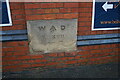
Old Boundary Marker in the wall on Copthorne Road, Shrewsbury
War Department Boundary Marker set in a brick wall on the north side of the B3486 Copthorne Road. Shrewsbury parish. Inscribed W (arrow) D / NO.XVII, with the remainder worn away but probably 2 FT S. The stone marks the boundary of Copthorne Barracks, see https://en.wikipedia.org/wiki/Copthorne_Barracks.
Milestone Society National ID: SA_WDSHRE17em
Image: © A Rowley
Taken: 3 Jan 2023
0.07 miles
2

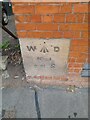
Old Boundary Marker in the wall on Copthorne Road, Shrewsbury
War Department Boundary Marker set in a brick wall on the north side of the B3486 Copthorne Road. Shrewsbury parish. Inscribed W (arrow) D / NO. 1 / 2 FT 6 IN W on the left face and W (arrow) D / NO. 1 / 2 FT S on the right face. The stone marks the boundary of Copthorne Barracks, see https://en.wikipedia.org/wiki/Copthorne_Barracks. See also https://www.geograph.org.uk/photo/7532733.
Milestone Society National ID: SA_WDSHRE01em
Image: © A Rowley
Taken: 3 Jan 2023
0.08 miles
4
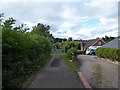
Footpath on Kellsall's Lane, Copthorne, Shrewsbury
A school access lane and access to a few residences.
Image: © Jeremy Bolwell
Taken: 27 Jun 2020
0.10 miles
5
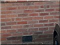
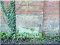
Ordnance Survey Cut Mark
This OS cut mark can be found on No48 Woodfield Road. It marks a point 76.815m above mean sea level.
Image: © Adrian Dust
Taken: 3 Jul 2023
0.12 miles
6
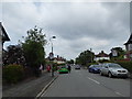
Part of Woodfield Road, Copthorne, Shrewsbury
Near the shop and mini roundabout.
Image: © Jeremy Bolwell
Taken: 11 Jun 2020
0.14 miles
7
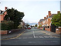
Granville Street, Copthorne, Shrewsbury
A residential street near the barracks.
Image: © Jeremy Bolwell
Taken: 20 Oct 2011
0.14 miles
8
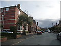
Part of Granville Street, Copthorne, Shrewsbury
Large old Victorian or Edwardian villas and semi-detached houses make up this section of the street.
Image: © Jeremy Bolwell
Taken: 20 Oct 2011
0.16 miles
9
War Department boundary marker
Built into the northern boundary wall of what was once Copthorne Barracks (Sir John Moore Barracks), the headquarters of the King's Shropshire Light Infantry from the 1880s until its disbandment in the mid 1990s. This stone is carved 'W D No IX, 6ft N', and there is another similar stone, albeit rather more weathered and somewhat illegible, at the base of a brick buttress a hundred yards or so further west Image
A couple more have survived the demolition and redevelopment of much of the barracks, and remain in the southern perimeter wall Image & Image
Image: © Richard Law
Taken: 6 Jan 2024
0.18 miles
10
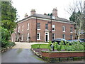
Cadogan House, Shrewsbury
Together with its former stable which lies (half hidden) to the right, this fine town house dates from around 1830, and was Grade II listed https://historicengland.org.uk/listing/the-list/list-entry/1270528 & https://britishlistedbuildings.co.uk/101270528-cadogan-house-and-stable-shrewsbury in 1972.
Image: © Richard Law
Taken: 6 Jan 2024
0.19 miles