IMAGES TAKEN NEAR TO
Longner Street, SHREWSBURY, SY3 8QU
Introduction
This page details the photographs taken nearby to Longner Street, SY3 8QU by members of the Geograph project.
The Geograph project started in 2005 with the aim of publishing, organising and preserving representative images for every square kilometre of Great Britain, Ireland and the Isle of Man.

There are currently over 7.5m images from over14,400 individuals and you can help contribute to the project by visiting https://www.geograph.org.uk
Image Map
Images are licensed for reuse under creativecommons.org/licenses/by-sa/2.0
Notes
- Clicking on the map will re-center to the selected point.
- The higher the marker number, the further away the image location is from the centre of the postcode.
Image Listing (494 Images Found)
Images are licensed for reuse under creativecommons.org/licenses/by-sa/2.0
Image
Details
Distance
1
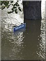
Frankwell car park
Floods at the end of October 2000 - taken by Seamus.
Image: © Bob Bowyer
Taken: 31 Oct 2000
0.04 miles
2
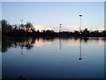
Flooded Frankwell car park, Shrewsbury
A clearer view of the inundation. The car park is deliberately allowed to flood, while barriers keep more important areas dry. See Image for more information.
Image: © David Gruar
Taken: 9 Dec 2006
0.05 miles
3
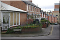
Mount Street, Mountfields
Looking down Mount Street from its junction with Alma Street.
Image: © Stephen McKay
Taken: 7 Mar 2009
0.05 miles
4
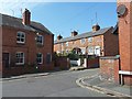
Olive Cottages
From the junction of Longner Street and Mount Street.
Image: © Penny Mayes
Taken: 5 Sep 2013
0.05 miles
5
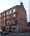
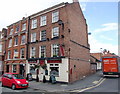
The Anchor Inn, Frankwell in Shrewsbury
As seen nowadays, the public house has the appearance of an 18th century building, but behind the brick outer lies an older, timber-framed construction, possibly 16th or 17th century, some of which is visible at the rear of the pub. It was Grade II listed https://britishlistedbuildings.co.uk/101247578-the-anchor-public-house-shrewsbury & https://historicengland.org.uk/listing/the-list/list-entry/1247578 in 1953.
Image: © Richard Law
Taken: 14 Jan 2023
0.06 miles
7
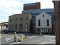
Theatre Severn
Seen from Whitehorse Passage (named for a pub which no longer exists).
The building incorporates a former Welsh Calvinistic Methodist Chapel. This chapel, designed by borough engineer T. Tisdale, was opened in 1865 to house a congregation of English-speaking Welsh Calvinistic Methodists. The congregation moved to a new building on Belmont Bank in 1905. The Frankwell Quay chapel continued in use as a mission church until 1909 when the building was sold.
The theatre stage door is just to the left of the chapel frontage.
Image: © Penny Mayes
Taken: 5 Sep 2013
0.07 miles
8
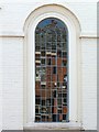
Reflections in chapel window
The window of the former Welsh Calvinistic Methodist Chapel incorporated into the Theatre Severn building http://www.geograph.org.uk/photo/3724502 provides a scattered reflection of the Old Anchor Inn across the street.
Image: © Penny Mayes
Taken: 5 Sep 2013
0.07 miles
10
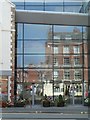
Reflections in Theatre Severn
Part of the Theatre Severn building http://www.geograph.org.uk/photo/3724502 provides a reflection of the Anchor Inn across the street.
Image: © Penny Mayes
Taken: 5 Sep 2013
0.07 miles