IMAGES TAKEN NEAR TO
The Mount, SHREWSBURY, SY3 8PT
Introduction
This page details the photographs taken nearby to The Mount, SY3 8PT by members of the Geograph project.
The Geograph project started in 2005 with the aim of publishing, organising and preserving representative images for every square kilometre of Great Britain, Ireland and the Isle of Man.

There are currently over 7.5m images from over14,400 individuals and you can help contribute to the project by visiting https://www.geograph.org.uk
Image Map
Images are licensed for reuse under creativecommons.org/licenses/by-sa/2.0
Notes
- Clicking on the map will re-center to the selected point.
- The higher the marker number, the further away the image location is from the centre of the postcode.
Image Listing (86 Images Found)
Images are licensed for reuse under creativecommons.org/licenses/by-sa/2.0
Image
Details
Distance
1
Old Toll House, Mountfield
Toll House in the parish of Shrewsbury, on The Mount (A458)
To be surveyed
Milestone Society National ID: SA.SHR03
Image: © Milestone Society
Taken: Unknown
0.03 miles
3
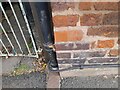
Ordnance Survey Cut Mark
This OS cut mark can be found on No18 The Mount. It marks a point 228.003ft above mean sea level.
Image: © Adrian Dust
Taken: 3 Jul 2023
0.04 miles
4
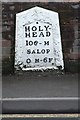
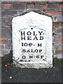
Old Milestone by the A458, The Mount, Shrewsbury
Metal plate attached to stone post by the A458, in parish of SHREWSBURY (SHREWSBURY AND ATCHAM District), Severn View; Hafren Road/The Mount, in pavement with back to wall, on South side of road. Telford gabled iron plate, erected by the Holyhead Road turnpike trust in the 19th century. The first milestone on the 'Holyhead Road'.
Inscription reads:-
HOLY-
HEAD
106- M
SALOP
0 M-6F.
Grade II listed.
List Entry Number: 1270527 https://historicengland.org.uk/listing/the-list/list-entry/1270527
Milestone Society National ID: SA_HH106.
Image: © A Reade/J Higgins
Taken: 8 Jul 2008
0.04 miles
5
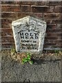
Old Milestone
Old milestone on what would have been the A.5 at Shrewsbury, Shropshire. For overall view see http://www.geograph.org.uk/photo/4244962
Image: © Keith Evans
Taken: 11 Oct 2014
0.05 miles
7
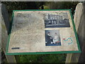
Information board in Doctor's Field below The Mount, Darwins home in Shrewsbury
Interesting and informative.
Image: © Jeremy Bolwell
Taken: 4 Jan 2021
0.05 miles
8
Holyhead 106
Old milestone on what would have been the A.5 at Shrewsbury, Shropshire. For close up view see http://www.geograph.org.uk/photo/4244961
Image: © Keith Evans
Taken: 11 Oct 2014
0.05 miles
9
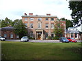
Darwin's birthplace; The Mount, Shrewsbury
Charles Darwin was born here in 1809. Not a bad place of origin, a handsome home with extensive outbuildings such as old coach house and stables, backing on to the River Severn and with extensive views.
Now marked on the map as 'government offices' the building houses the district valuer's offices.
Image: © Jeremy Bolwell
Taken: 26 Sep 2011
0.07 miles
10
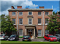
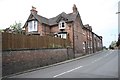
The Mount, Frankwell, Shrewsbury
Built for Robert Darwin, c1796, in pink brick with red brick dressings. The Doric porch is a slightly later addition. Grade II* listed.
The architecture is trumped by the fact that Robert's most famous son, Charles, was born here in 1809. Charles attended Shrewsbury School, but otherwise the claim to fame seems a bit of a stretch. At the time the buildings served as the District Valuer and Valuation Office of Shrewsbury.
Image: © Stephen Richards
Taken: 13 May 2014
0.08 miles