IMAGES TAKEN NEAR TO
Breidden View, SHREWSBURY, SY3 8NN
Introduction
This page details the photographs taken nearby to Breidden View, SY3 8NN by members of the Geograph project.
The Geograph project started in 2005 with the aim of publishing, organising and preserving representative images for every square kilometre of Great Britain, Ireland and the Isle of Man.

There are currently over 7.5m images from over14,400 individuals and you can help contribute to the project by visiting https://www.geograph.org.uk
Image Map
Images are licensed for reuse under creativecommons.org/licenses/by-sa/2.0
Notes
- Clicking on the map will re-center to the selected point.
- The higher the marker number, the further away the image location is from the centre of the postcode.
Image Listing (172 Images Found)
Images are licensed for reuse under creativecommons.org/licenses/by-sa/2.0
Image
Details
Distance
1
Ordnance Survey Cut Mark
This OS cut mark can be found on No63 Copthorne Road. It marks a point 70.026m above mean sea level.
Image: © Adrian Dust
Taken: 3 Jul 2023
0.02 miles
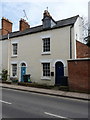
3
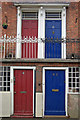
Doors on New Street
An unusual arrangement of upper and lower doors - part of Providence Terrace on New Street in the Frankwell district of Shrewsbury. Note the ornate railings on the upper storey.
Image: © Stephen McKay
Taken: 7 Mar 2009
0.10 miles
4
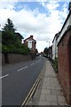
New Street
Looking along New Street near Water Lane.
Image: © DS Pugh
Taken: 29 Jul 2018
0.10 miles
6
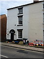
53 New Street, Shrewsbury
The lefthand end of a terrace of 5 similar houses, which were all built around the 1840s, and which were collectively Grade II listed https://britishlistedbuildings.co.uk/101254696-53-57-new-street-shrewsbury#.XJfWzyj7TIU in 1972.
Image: © Richard Law
Taken: 23 Mar 2019
0.11 miles
7
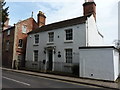
59 New Street, Shrewsbury
Located in the Frankwell area of the town, no 59 is an early 19th century house which was Grade II listed https://britishlistedbuildings.co.uk/101270673-59-new-street-shrewsbury#.XJfVayj7TIU in 1972.
Image: © Richard Law
Taken: 23 Mar 2019
0.11 miles
8
56 & 57 New Street, Shrewsbury
The right-most end of a terrace of 5 similar houses, numbered 53 to 57; they were collectively Grade II listed https://britishlistedbuildings.co.uk/101254696-53-57-new-street-shrewsbury#.XJfWzyj7TIU in 1972, and date from around 1840.
Image: © Richard Law
Taken: 23 Mar 2019
0.11 miles
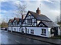
9
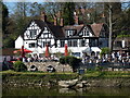
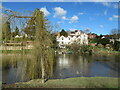
The Boathouse Inn
Seen here from the other river bank, this Grade II listed building https://www.britishlistedbuildings.co.uk/101270652-the-boathouse-inn-shrewsbury#.WQNC6tQrLGg was granted its listing in 1953. It's believed to date, in parts at least, from the late 16th century, although there have been alterations in the intervening years, and the original structure is described as a 'long range, with cross wing', which rather suggests it was perhaps a farmhouse or similar. These days, especially on a warm spring weekend, it's a very popular watering hole and pub.
Image: © Richard Law
Taken: 8 Apr 2017
0.12 miles