IMAGES TAKEN NEAR TO
SHREWSBURY, SY3 7AS
Introduction
This page details the photographs taken nearby to SY3 7AS by members of the Geograph project.
The Geograph project started in 2005 with the aim of publishing, organising and preserving representative images for every square kilometre of Great Britain, Ireland and the Isle of Man.

There are currently over 7.5m images from over14,400 individuals and you can help contribute to the project by visiting https://www.geograph.org.uk
Image Map
Images are licensed for reuse under creativecommons.org/licenses/by-sa/2.0
Notes
- Clicking on the map will re-center to the selected point.
- The higher the marker number, the further away the image location is from the centre of the postcode.
Image Listing (272 Images Found)
Images are licensed for reuse under creativecommons.org/licenses/by-sa/2.0
Image
Details
Distance
1
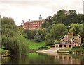
Shrewsbury School with private boathouse
Image: © Flying Stag
Taken: 7 Oct 2013
0.04 miles
2
Shrewsbury School from the Riverside Walk
Image: © Peter Turner
Taken: 13 Aug 2016
0.04 miles
3
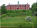
Shrewsbury School, Ashton Road, Shrewsbury
This is the main building, built as a foundling hospital in 1759-65 to the designs of Thomas Farnolls Pritchard. The clock turret and various other decorative touches belong to Arthur Blomfield's alterations for the school, c1880. Grade II listed.
Image: © Stephen Richards
Taken: 12 May 2014
0.04 miles
4
Shrewsbury School
The Grade II listed https://historicengland.org.uk/listing/the-list/list-entry/1271368 main building was originally Coram's Foundling Hospital built in 1765 by Thomas Farnoils Pritchard. The hospital closed in 1772 and the building was as a woollen factory and later an asylum before being acquired in 1882 by Sir Arthur Blomfield for the use of Shrewsbury School.
Image
Image
Image: © Gerald England
Taken: 21 Jul 2019
0.04 miles
5
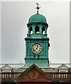
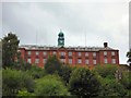
Shrewsbury School: Cupola
The cupola was added to the original building Image in 1882.
Image: © Gerald England
Taken: 21 Jul 2019
0.04 miles
6
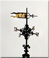
Shrewsbury School: Weathervane
On the top of Shrewsbury School Image
Image: © Gerald England
Taken: 21 Jul 2019
0.04 miles
7
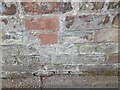
Ordnance Survey Cut Mark
This OS cut mark can be found on the wall of No11 Canonbury. It marks a point 75.368m above mean sea level.
Image: © Adrian Dust
Taken: 4 Jul 2023
0.04 miles
8
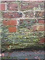
OS benchmark - Kingsland, wall on Canonbury
An OS cutmark on the wall of no 11 Canonbury; originally levelled in 1951 at 75.368m above Ordnance Datum Newlyn.
Image: © Richard Law
Taken: 7 Jan 2017
0.05 miles
9
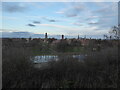
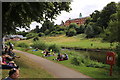
View to Shrewsbury's townscape on a late December afternoon
The skyline or townscape of this town is very fine I think.
Image: © Jeremy Bolwell
Taken: 30 Dec 2020
0.05 miles
10
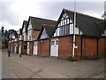
Shrewsbury School boathouse
More or less adjacent to the Boating Club buildings in Image; a well-signed public footpath runs along this bank of the river, crossing through the grounds of both clubs.
Image: © Richard Law
Taken: 14 Feb 2010
0.05 miles