IMAGES TAKEN NEAR TO
Kennedy Road, SHREWSBURY, SY3 7AA
Introduction
This page details the photographs taken nearby to Kennedy Road, SY3 7AA by members of the Geograph project.
The Geograph project started in 2005 with the aim of publishing, organising and preserving representative images for every square kilometre of Great Britain, Ireland and the Isle of Man.

There are currently over 7.5m images from over14,400 individuals and you can help contribute to the project by visiting https://www.geograph.org.uk
Image Map
Images are licensed for reuse under creativecommons.org/licenses/by-sa/2.0
Notes
- Clicking on the map will re-center to the selected point.
- The higher the marker number, the further away the image location is from the centre of the postcode.
Image Listing (19 Images Found)
Images are licensed for reuse under creativecommons.org/licenses/by-sa/2.0
Image
Details
Distance
1
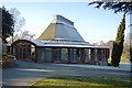
Maidment Centre
Purpose built music school at Shrewsbury School opened by the Prince of Wales in 2001. The building has acoustic wall panels in the main 220 seat elliptical auditorium, teaching rooms and a recording studio.
Image: © John M
Taken: 29 Dec 2016
0.02 miles
2
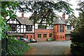
39 Kennedy Road, Shrewsbury
The grandest of Kingsland's Victorian houses, long and low in Domestic Revival style. It was built in 1885-86 to the design of T.M. Lockwood who usually plied his trade around Chester.
Image: © Stephen Richards
Taken: 13 May 2014
0.06 miles
3

Pillar Box - No Royal Cipher
A Type-B Pillar Box on Kennedy Road, Kingsland in Shrewsbury. That it has no royal cipher indicates that it pre-dates the use of VR (Victoria Regina) and therefore dates from 1850s - 1880s.
What3Words: crash.sugars.farm
Image: © Anthony Rowley
Taken: 12 Jun 2021
0.06 miles
4
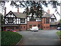
Mansion style home on Kennedy Road, Kingsland, Shrewsbury
What an amazing property - it is a single house and must have once been someone's new home. I wonder who the first residents were..?
Image: © Jeremy Bolwell
Taken: 3 Oct 2011
0.06 miles
6
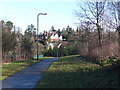
Looking across to Kingsland
Taken from the public footpath the other side of Roman Road
Image: © Marion Haworth
Taken: 19 Jan 2011
0.09 miles
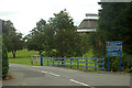
7
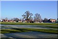
Playing fields at Shrewsbury School
The morning frost is slow to lift and may stay all day.
Image: © John M
Taken: 29 Dec 2016
0.10 miles
8

Roman Road approaching Ridgebourne Road
Image: © Peter Whatley
Taken: 6 Jul 2013
0.11 miles
9
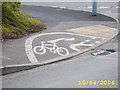
5ft cycle path
Here is a cycle path in Shrewsbury that is as small as an actual bike.
Image: © Mr M Evison
Taken: 16 Apr 2006
0.11 miles
10
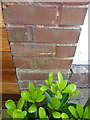
OS benchmark - Meole Brace, 44 Roman Road
An OS cutmark on the wall of no 44 Roman Road; originally levelled in 1951 at 69.121m above Ordnance Datum Newlyn.
Image: © Richard Law
Taken: 5 May 2017
0.11 miles