IMAGES TAKEN NEAR TO
Winterton Way, SHREWSBURY, SY3 5PA
Introduction
This page details the photographs taken nearby to Winterton Way, SY3 5PA by members of the Geograph project.
The Geograph project started in 2005 with the aim of publishing, organising and preserving representative images for every square kilometre of Great Britain, Ireland and the Isle of Man.

There are currently over 7.5m images from over14,400 individuals and you can help contribute to the project by visiting https://www.geograph.org.uk
Image Map
Images are licensed for reuse under creativecommons.org/licenses/by-sa/2.0
Notes
- Clicking on the map will re-center to the selected point.
- The higher the marker number, the further away the image location is from the centre of the postcode.
Image Listing (23 Images Found)
Images are licensed for reuse under creativecommons.org/licenses/by-sa/2.0
Image
Details
Distance
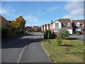
1
Part of Larkhill Road, Shelton, Shrewsbury
Someone is moving in or moving out. Good luck to them whichever applies. Nice road.
Image: © Jeremy Bolwell
Taken: 24 Oct 2011
0.09 miles
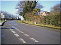
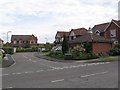
2
Parting of the ways on Shelton Road
The A458 bears off left heading for the Shrewsbury Ring Road (A5) while the B4380 bears right, eventually also to join the A5 farther out of Shrewsbury at Montford Bridge.
Image: © Peter Whatley
Taken: 6 Jul 2013
0.09 miles
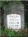
3
Holyhead 105
Old milestone on what would have been the A.5 at Shrewsbury, Shropshire. For close up view see http://www.geograph.org.uk/photo/4776073
Image: © Keith Evans
Taken: 17 Oct 2015
0.13 miles
4
Part of Napoleon Drive, Shelton, Shrewsbury
A typical quiet modern suburban road with a curious choice of name maybe. Ironically a 'mental health village' is being built close by. No joke.
Image: © Jeremy Bolwell
Taken: 26 Sep 2011
0.14 miles
5
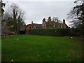
Part of Shelton Hall Gardens, Shrewsbury
Part of the original hall building is visible, now surrounded by modern executive style houses.
Image: © Jeremy Bolwell
Taken: 30 Nov 2011
0.15 miles
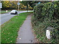
6
Old Milestone
Old milestone on what would have been the A.5 at Shrewsbury, Shropshire. For overall view see http://www.geograph.org.uk/photo/4776077
Image: © Keith Evans
Taken: 17 Oct 2015
0.16 miles
8
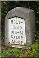
Old Milestone by the A458, Shelton, Shrewsbury parish
Metal plate (replica) attached to stone post by the A458 (was A5), in parish of SHREWSBURY (SHREWSBURY AND ATCHAM District), Shelton, junction with The Mount, on North side of road. Telford gabled iron plate, erected by the Holyhead Road turnpike trust in the 19th century.
Inscription reads:-
HOLY-
HEAD
105 - M
SALOP
1M - 6F
Shropshire HER.
HER Number (PRN): 21052 https://www.heritagegateway.org.uk/Gateway/Results_Single.aspx?uid=MSA23607&resourceID=1015
Milestone Society National ID: SA_HH105.
Image: © A Reade/J Higgins
Taken: 8 Jul 2008
0.17 miles
9
The Shelton milestone - detail
Holyhead - 105 miles, Salop - 1 mile, 6 furlongs. The placename and the distance are quite evocative.
Image: © Richard Law
Taken: 21 Feb 2010
0.17 miles