IMAGES TAKEN NEAR TO
The Dell, SHREWSBURY, SY3 5HG
Introduction
This page details the photographs taken nearby to The Dell, SY3 5HG by members of the Geograph project.
The Geograph project started in 2005 with the aim of publishing, organising and preserving representative images for every square kilometre of Great Britain, Ireland and the Isle of Man.

There are currently over 7.5m images from over14,400 individuals and you can help contribute to the project by visiting https://www.geograph.org.uk
Image Map
Images are licensed for reuse under creativecommons.org/licenses/by-sa/2.0
Notes
- Clicking on the map will re-center to the selected point.
- The higher the marker number, the further away the image location is from the centre of the postcode.
Image Listing (11 Images Found)
Images are licensed for reuse under creativecommons.org/licenses/by-sa/2.0
Image
Details
Distance
2
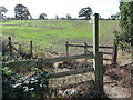
Finger post and stile on a footpath near Gains Park, Shrewsbury
An inviting prospect - a path disappaering off to who knows where, the sun is shining and the grass is greener on the other side.
Image: © Jeremy Bolwell
Taken: 18 Oct 2011
0.13 miles
3
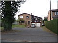
1970's style detached house on Racecourse Lane, Shrewsbury
This house may well date from a different decade but it seem very 1970's in essence; large windows, open plan sitting room and lots of roof. Interesting property.
Image: © Jeremy Bolwell
Taken: 24 Oct 2011
0.13 miles
4
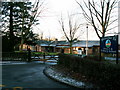
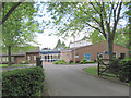
Oxon Primary School
Racecourse Lane sees a mixture of health service, education services, modern housing and an old farm. Bicton Heath, Shrewsbury, Shropshire.
Image: © Keith Havercroft
Taken: 5 Mar 2006
0.13 miles
6

Vehicle parked out of doors near Gains Park, Shrewsbury
This vehicle seems to have its best days behind it.
Image: © Jeremy Bolwell
Taken: 18 Oct 2011
0.18 miles
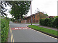
7
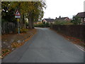
Part of Racecourse Lane, Shrewsbury
A very nice residential road.
Image: © Jeremy Bolwell
Taken: 24 Oct 2011
0.23 miles
8
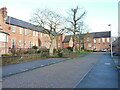
The former Shelton Hospital
Shelton Hospital started life as Shropshire and Wenlock Borough Lunatic Asylum in March 1845, a name which certainly wouldn't pass muster these days! It was extended about 30 years later, and then renamed as the Salop Mental Hospital just after WW1. It closed as a National Health Service facility in 2012, and whilst some of the smaller buildings on site have been demolished, the main ward blocks and the chapel have been converted to housing; it now sits in the middle of the extensive Leighton Park housing estate. The whole main block was Grade II listed https://britishlistedbuildings.co.uk/101270532-shelton-hospital-shrewsbury & https://historicengland.org.uk/listing/the-list/list-entry/1270532 in 1993.
Image: © Richard Law
Taken: 6 Jan 2024
0.24 miles
9
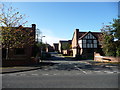
The entrance to Bowbrook Grange, Gains Park, Shrewsbury
A small select estate of large detached homes, formed into small closes and cul-de-sacs offering privacy and security for residents.
Image: © Jeremy Bolwell
Taken: 18 Oct 2011
0.24 miles
10
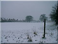
Public Footpath
A footpath is preserved in this winter view across a playing field between modern housing and health service developments
Image: © Keith Havercroft
Taken: 12 Mar 2006
0.25 miles