IMAGES TAKEN NEAR TO
Yew Tree Drive, SHREWSBURY, SY3 0PP
Introduction
This page details the photographs taken nearby to Yew Tree Drive, SY3 0PP by members of the Geograph project.
The Geograph project started in 2005 with the aim of publishing, organising and preserving representative images for every square kilometre of Great Britain, Ireland and the Isle of Man.

There are currently over 7.5m images from over14,400 individuals and you can help contribute to the project by visiting https://www.geograph.org.uk
Image Map
Images are licensed for reuse under creativecommons.org/licenses/by-sa/2.0
Notes
- Clicking on the map will re-center to the selected point.
- The higher the marker number, the further away the image location is from the centre of the postcode.
Image Listing (6 Images Found)
Images are licensed for reuse under creativecommons.org/licenses/by-sa/2.0
Image
Details
Distance
1
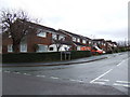
Glebe Road, Bayston Hill
A dormitary village to the south of Shrewsbury.
Image: © Jonathan Billinger
Taken: 6 Dec 2007
0.05 miles
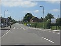
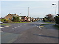
2
Glebe Road, Bayston Hill
Junction with Yew Tree drive. Taken when lost, looking for Lyth Hill. (GR recorded on GPS at the time - it knew where I was)
Image: © Richard Webb
Taken: 30 Jul 2009
0.14 miles
3
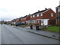
Eric Lock Road West
Suburban housing in Bayston Hill, south of Shrewsbury.
Image: © Jonathan Billinger
Taken: 6 Dec 2007
0.16 miles
4
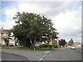
Crossroads in Bayston Hill
Looking down Lythwood Road, from the crossing with Glebe Road (to the right) and Ovrdale Road (on the left)
Image: © Richard Law
Taken: 28 Jan 2012
0.22 miles
5
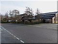
Christ Church, Bayston Hill
A modern church on Glebe Road, Bayston Hill.
www.baystonhillchurch.org
Image: © Richard Law
Taken: 28 Jan 2012
0.22 miles