IMAGES TAKEN NEAR TO
Lythwood Road, SHREWSBURY, SY3 0NA
Introduction
This page details the photographs taken nearby to Lythwood Road, SY3 0NA by members of the Geograph project.
The Geograph project started in 2005 with the aim of publishing, organising and preserving representative images for every square kilometre of Great Britain, Ireland and the Isle of Man.

There are currently over 7.5m images from over14,400 individuals and you can help contribute to the project by visiting https://www.geograph.org.uk
Image Map
Images are licensed for reuse under creativecommons.org/licenses/by-sa/2.0
Notes
- Clicking on the map will re-center to the selected point.
- The higher the marker number, the further away the image location is from the centre of the postcode.
Image Listing (13 Images Found)
Images are licensed for reuse under creativecommons.org/licenses/by-sa/2.0
Image
Details
Distance
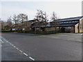
1
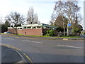
Bayston Hill library
At the corner of Glebe Road and Lythwood Road.
Image: © Richard Law
Taken: 28 Jan 2012
0.01 miles
2
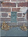
OS flush bracket 2880 - Upper Pulley
Flush Bracket 2880 affixed to a former farm building at Upper Pulley; originally levelled in early 1920 at fractionally over 322ft above Ordnance Datum Newlyn.
Image: © Richard Law
Taken: 4 Jul 2015
0.04 miles
3
Missing (in action?) and now relocated
The 'legendary' missing trig of Overley Hill, which originally stood on a small hill just north of The Wrekin in Image, but fell victim in 1990 to the construction of the new A5 dual carriageway. It was rescued at the time http://trigpointinguk-photos.s3.amazonaws.com/089/P89058.jpg by a local firm of surveyors, the Severn Partnership Ltd, and now stands proudly outside their offices in Bayston Hill, about 8 miles from its original location. http://www.trigpointinguk.com/trigs/trig-details.php?t=5259
Update early 2019... The wandering trig of east Shropshire's gone walkabout again. The Severn Partnership business referred to above have relocated to a modern business park on the north side of Telford, not far from Image, and have apparently taken the trig with them, where it now effectively acts as their 'Gate Guardian' emblem. It's now roughly 4 miles from its original location on Overley Hill, rather than about 8 miles away and this is what it looked like in 2020 Image
Image: © Richard Law
Taken: 28 Jan 2012
0.04 miles
4
Trig point surrounded with buildings
The number of this Trig point is showing OSBM S1912 http://www.bench-marks.org.uk/bm3836 and flush bracket on the building is OSBM 2880 http://www.bench-marks.org.uk/bm2289 , it's almost as if this trig point doesn't belong here
Image: © Mr M Evison
Taken: 7 Mar 2010
0.08 miles
6
Christ Church, Bayston Hill
A modern church on Glebe Road, Bayston Hill.
www.baystonhillchurch.org
Image: © Richard Law
Taken: 28 Jan 2012
0.14 miles
7
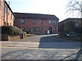
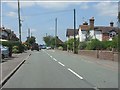
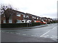
Lyth Hill Road, Bayston Hill
Large area of post war housing just outside Shrewsbury. The green belt, if there is one, between Shrewsbury and Bayston Hill is very strained, and there is little agricultural land left now between the two.
Image: © Richard Webb
Taken: 30 Jul 2009
0.14 miles
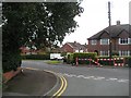
8
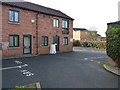
Bayston Hill - Lyth Hill Road at Lythwood Road
Image: © Peter Whatley
Taken: 6 Jul 2013
0.17 miles
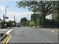
9
Eric Lock Road West
Suburban housing in Bayston Hill, south of Shrewsbury.
Image: © Jonathan Billinger
Taken: 6 Dec 2007
0.20 miles
10
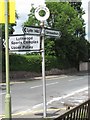
Old Direction Sign - Signpost by Cross Roads, Bayston Hill parish
Annulus finial - 3 Worboys arms; Shropshire CC modern halo by the UC road, in parish of Bayston Hill (Shrewsbury and Atcham District), Bayston Hill (Lyth Hill).
Surveyed
Milestone Society National ID: SA_SJ4808A
Image: © Milestone Society
Taken: Unknown
0.20 miles