IMAGES TAKEN NEAR TO
Langford Avenue, SHREWSBURY, SY3 0JU
Introduction
This page details the photographs taken nearby to Langford Avenue, SY3 0JU by members of the Geograph project.
The Geograph project started in 2005 with the aim of publishing, organising and preserving representative images for every square kilometre of Great Britain, Ireland and the Isle of Man.

There are currently over 7.5m images from over14,400 individuals and you can help contribute to the project by visiting https://www.geograph.org.uk
Image Map
Images are licensed for reuse under creativecommons.org/licenses/by-sa/2.0
Notes
- Clicking on the map will re-center to the selected point.
- The higher the marker number, the further away the image location is from the centre of the postcode.
Image Listing (6 Images Found)
Images are licensed for reuse under creativecommons.org/licenses/by-sa/2.0
Image
Details
Distance
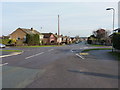
4
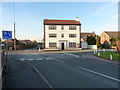
Road junction in Bayston Hill
A mini roundabout at the junction of Overdale Road, Gorse Lane, Pulley Lane and Landsdowne Road.
Image: © Richard Law
Taken: 28 Jan 2012
0.21 miles
5
Crossroads in Bayston Hill
Looking down Lythwood Road, from the crossing with Glebe Road (to the right) and Ovrdale Road (on the left)
Image: © Richard Law
Taken: 28 Jan 2012
0.22 miles
6
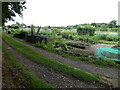
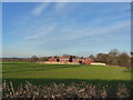
Allotments at Bayston Hill south of Shrewsbury
Well tended and productive allotments. Lots of hard work, but also a great way to relax - and homegrown always tastes better!
Image: © Andrew Shannon
Taken: 28 Jun 2023
0.24 miles