IMAGES TAKEN NEAR TO
Ferndale, Betley Lane, SHREWSBURY, SY3 0HF
Introduction
This page details the photographs taken nearby to Ferndale, Betley Lane, SY3 0HF by members of the Geograph project.
The Geograph project started in 2005 with the aim of publishing, organising and preserving representative images for every square kilometre of Great Britain, Ireland and the Isle of Man.

There are currently over 7.5m images from over14,400 individuals and you can help contribute to the project by visiting https://www.geograph.org.uk
Image Map
Images are licensed for reuse under creativecommons.org/licenses/by-sa/2.0
Notes
- Clicking on the map will re-center to the selected point.
- The higher the marker number, the further away the image location is from the centre of the postcode.
Image Listing (9 Images Found)
Images are licensed for reuse under creativecommons.org/licenses/by-sa/2.0
Image
Details
Distance
1
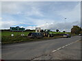
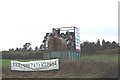
At a road junction on the A49 just south of Bayston Hill, near Shrewsbury
The farm workers here are erecting an advertisement for Christmas turkeys. Every year it sits here and encourages people to order their bird from a certain provider in good time for Christmas. The black sileage bag becomes the body of the turkey. I will return and get the shot showing the finished article.
Image: © Jeremy Bolwell
Taken: 28 Oct 2020
0.19 miles
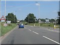
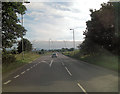
3

A49 at the entrance to Bayston Hill
An earlier alignment provides a layby to the east of the current road.
Image: © Peter Whatley
Taken: 6 Jul 2013
0.20 miles
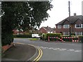
4
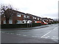
Eric Lock Road West
Suburban housing in Bayston Hill, south of Shrewsbury.
Image: © Jonathan Billinger
Taken: 6 Dec 2007
0.21 miles
5
Christ Church, Bayston Hill
A modern church on Glebe Road, Bayston Hill.
www.baystonhillchurch.org
Image: © Richard Law
Taken: 28 Jan 2012
0.21 miles
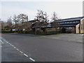
7
A49 junction with unnamed lane to Condover
Image: © Stuart Logan
Taken: 20 Sep 2013
0.21 miles
8
Lyth Hill Road, Bayston Hill
Large area of post war housing just outside Shrewsbury. The green belt, if there is one, between Shrewsbury and Bayston Hill is very strained, and there is little agricultural land left now between the two.
Image: © Richard Webb
Taken: 30 Jul 2009
0.21 miles
9
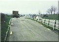
Lay-by beside the A49 in 1987
Just south of Bayston Hill.
Image: © John Baker
Taken: 9 Apr 1987
0.22 miles