IMAGES TAKEN NEAR TO
Hereford Road, SHREWSBURY, SY3 0DU
Introduction
This page details the photographs taken nearby to Hereford Road, SY3 0DU by members of the Geograph project.
The Geograph project started in 2005 with the aim of publishing, organising and preserving representative images for every square kilometre of Great Britain, Ireland and the Isle of Man.

There are currently over 7.5m images from over14,400 individuals and you can help contribute to the project by visiting https://www.geograph.org.uk
Image Map
Images are licensed for reuse under creativecommons.org/licenses/by-sa/2.0
Notes
- Clicking on the map will re-center to the selected point.
- The higher the marker number, the further away the image location is from the centre of the postcode.
Image Listing (54 Images Found)
Images are licensed for reuse under creativecommons.org/licenses/by-sa/2.0
Image
Details
Distance
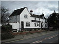
3
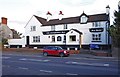
The Compasses Inn (1), Hereford Road, Bayston Hill
Image: © P L Chadwick
Taken: 25 Feb 2012
0.02 miles
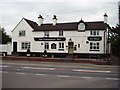
4
The Compasses Inn (2), Hereford Road, Bayston Hill
The pub is well-known for its nautical curios, including the front of a boat in the bar.
Image
Image
Image: © P L Chadwick
Taken: 25 Feb 2012
0.02 miles
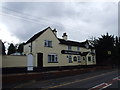
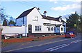
5
The Compasses Inn, Bayston Hill
This public house is situated on Hereford Road (A49) in Bayston Hill.
Image: © Andrew Bennett
Taken: 22 Apr 2007
0.02 miles
6
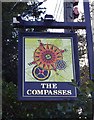
The Compasses Inn (3) - sign, Hereford Road, Bayston Hill
There are three compasses on the sign. The pub name, which is fairly common, could be connected with a trade guild or possibly the pub once had masonic connections, as the compass is a masonic symbol.
Image
Image
Image: © P L Chadwick
Taken: 25 Feb 2012
0.03 miles
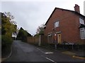
7
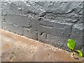
Ordnance Survey Cut Mark
This OS cut mark can be found on The Compasses Inn. It marks a point 97.579m above mean sea level.
Image: © Adrian Dust
Taken: 5 Jul 2023
0.03 miles
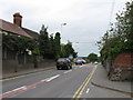
8
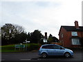
Part of Hereford Road in Bayston Hill, Shrewsbury
Busy A49 the main north-south road through Salop.
Image: © Jeremy Bolwell
Taken: 10 Nov 2016
0.04 miles