IMAGES TAKEN NEAR TO
Abbey Foregate, SHREWSBURY, SY2 6LY
Introduction
This page details the photographs taken nearby to Abbey Foregate, SY2 6LY by members of the Geograph project.
The Geograph project started in 2005 with the aim of publishing, organising and preserving representative images for every square kilometre of Great Britain, Ireland and the Isle of Man.

There are currently over 7.5m images from over14,400 individuals and you can help contribute to the project by visiting https://www.geograph.org.uk
Image Map
Images are licensed for reuse under creativecommons.org/licenses/by-sa/2.0
Notes
- Clicking on the map will re-center to the selected point.
- The higher the marker number, the further away the image location is from the centre of the postcode.
Image Listing (129 Images Found)
Images are licensed for reuse under creativecommons.org/licenses/by-sa/2.0
Image
Details
Distance
1
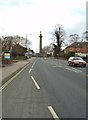
Abbey Foregate View
The view towards the Lord Hill monument in Shrewsbury.
Image: © Gordon Griffiths
Taken: 21 Apr 2013
0.01 miles
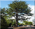
2
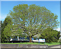
Tree, Abbey Foregate, Shrewsbury
A splendid spreading specimen. It has the right sort of leaves to be an ash.
Image: © Stephen Richards
Taken: 12 May 2014
0.02 miles
3
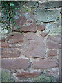
Forgotten OS benchmark - Shirehall, south side of Abbey Foregate
A badly weathered, and unrecorded (OS?) benchmark in a wall more or less opposite Shirehall. It's not mentioned by the OS's own website, so its height cannot be noted here.
Image: © Richard Law
Taken: 26 Sep 2015
0.02 miles
4
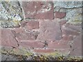
Ordnance Survey Cut Mark
This OS cut mark can be found on the wall SW side of Abbey Foregate.
Image: © Adrian Dust
Taken: 4 Jul 2023
0.02 miles
5
Cedar, Abbey Foregate, Shrewsbury
At the entrance to the Shire Hall car park. I think it's a cedar but not sure.
Image: © Stephen Richards
Taken: 12 May 2014
0.04 miles
6
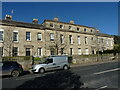
121 - 124 Abbey Foregate, Shrewsbury
A row of substantial, early 19th century houses, built around 1820. The terrace was Grade II listed in 1953, along with the garden wall, gatepiers and balustraded fencing which abuts the footway https://britishlistedbuildings.co.uk/101246326-121-124-abbey-foregate-and-garden-walls-shrewsbury & https://historicengland.org.uk/listing/the-list/list-entry/1246326.
Image: © Richard Law
Taken: 20 Apr 2023
0.05 miles
7
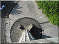
View down from Lord Hill's Column (2)
The foundation stone for this column was laid in December 1814 and finished in June 1816.
It is 133 feet tall and cost £5,972 13s 2d to build and contains 172 steps.
Image: © Dave Croker
Taken: 13 Oct 2009
0.05 miles
8
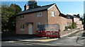
131 Abbey Foregate, Shrewsbury
A fairly plain early 19th century house or cottage, which was Grade II listed https://britishlistedbuildings.co.uk/101246328-131-abbey-foregate-shrewsbury & https://historicengland.org.uk/listing/the-list/list-entry/1246328 in 1953. Until recently it had a 2nd chimney stack above the right gable, but that seems to have been removed. The steel fencing is associated with rebuilding work at the adjacent Image which was in the process of conversion to flats at the time of this picture.
Image: © Richard Law
Taken: 20 Apr 2023
0.05 miles
9
The council chamber at Shirehall
The long shadow on the left is from the Column http://www.geograph.org.uk/photo/1534682
Image: © Dave Croker
Taken: 13 Oct 2009
0.05 miles
10
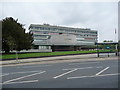
Shire Hall, Shrewsbury
One of those ground breaking, mould breaking 1960's buildings aimed at being futuristic, efficient and long-lasting. But having a flat roof, windows that allow it to be cold in winter and over hot in summer and designed in such a way that as a first time visitor youre never totally sure where the main entrance door is. Nothing says ' faceless bureaucracy' more than a county hall type building of this date.
Image: © Jeremy Bolwell
Taken: 4 May 2012
0.05 miles