IMAGES TAKEN NEAR TO
Millmead Drive, SHREWSBURY, SY2 6DU
Introduction
This page details the photographs taken nearby to Millmead Drive, SY2 6DU by members of the Geograph project.
The Geograph project started in 2005 with the aim of publishing, organising and preserving representative images for every square kilometre of Great Britain, Ireland and the Isle of Man.

There are currently over 7.5m images from over14,400 individuals and you can help contribute to the project by visiting https://www.geograph.org.uk
Image Map
Images are licensed for reuse under creativecommons.org/licenses/by-sa/2.0
Notes
- Clicking on the map will re-center to the selected point.
- The higher the marker number, the further away the image location is from the centre of the postcode.
Image Listing (21 Images Found)
Images are licensed for reuse under creativecommons.org/licenses/by-sa/2.0
Image
Details
Distance
1
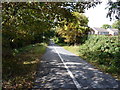
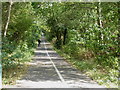
The former railway line into Shrewsbury
The route of the former line from the Severn Valley direction (Bridgnorth, Ironbridge, Buildwas, Cressage etc) into Shrewsbury; now used as a shared cycle and pedestrian route.
Image: © Richard Law
Taken: 12 Sep 2011
0.12 miles
2
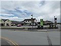
The Charles Darwin public house, Sutton Farm, Shrewsbury
Looks closed.
Image: © Jeremy Bolwell
Taken: 28 Jun 2020
0.12 miles
3
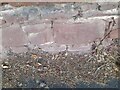
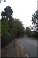
Ordnance Survey Cut Mark
This OS cut mark can be found on the wall west side of Sutton Road. It marks a point 68.940m above mean sea level.
Image: © Adrian Dust
Taken: 4 Jul 2023
0.13 miles
5
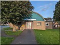
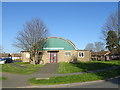
St. Giles' Memorial Hall, Sutton, Shrewsbury
St. Giles Church Hall, Sutton.
Image: © TCExplorer
Taken: 3 Oct 2023
0.14 miles
6
Springfield Way, Shrewsbury
Off Sutton Way.
Image: © JThomas
Taken: 28 Mar 2019
0.15 miles
8
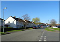
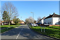
Sutton Road, Shrewsbury
Passing through an established suburb.
Image: © Richard Webb
Taken: 11 Oct 2017
0.16 miles
9
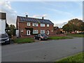
40 / 42 Sutton Way, Shrewsbury
Semi-detached housing with photovoltaic solar panels on the roof.
Image: © TCExplorer
Taken: 3 Oct 2023
0.18 miles
10
The former railway line out of Shrewsbury
The route of the former line towards the Severn Valley direction (Bridgnorth, Ironbridge, Buildwas, Cressage etc) from Shrewsbury; now used as a shared cycle and pedestrian route.
Image: © Richard Law
Taken: 12 Sep 2011
0.19 miles