IMAGES TAKEN NEAR TO
Bland Close, SHREWSBURY, SY2 5WH
Introduction
This page details the photographs taken nearby to Bland Close, SY2 5WH by members of the Geograph project.
The Geograph project started in 2005 with the aim of publishing, organising and preserving representative images for every square kilometre of Great Britain, Ireland and the Isle of Man.

There are currently over 7.5m images from over14,400 individuals and you can help contribute to the project by visiting https://www.geograph.org.uk
Image Map
Images are licensed for reuse under creativecommons.org/licenses/by-sa/2.0
Notes
- Clicking on the map will re-center to the selected point.
- The higher the marker number, the further away the image location is from the centre of the postcode.
Image Listing (11 Images Found)
Images are licensed for reuse under creativecommons.org/licenses/by-sa/2.0
Image
Details
Distance
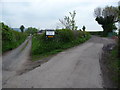
1
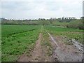
Footpath towards the River Severn
The path here descends in a straightish line to the river bank.
Image: © Jeremy Bolwell
Taken: 4 May 2012
0.10 miles
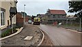
3

Construction of new housing estate
Construction of the 'Weir Hill' housing development by Taylor Wimpey and Persimmon Homes.
Image: © TCExplorer
Taken: 12 Jan 2020
0.15 miles
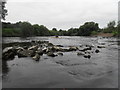
4
Downstream to the old weir
The ripples in the water about 100 yards away mark the location of the Image
Image: © Richard Law
Taken: 26 Sep 2015
0.18 miles
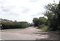
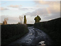
8
Fork in the lane
The track on the left heads towards Weir Hill Farm and the right fork heads towards the river, carrying the footpath.
Image: © Jeremy Bolwell
Taken: 4 May 2012
0.21 miles
9
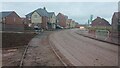
Recently constructed homes by Persimmon and Taylor Wimpey at Weir Hill
Recently constructed homes by Persimmon Homes and Taylor Wimpey on the Weir Hill development in Shrewsbury.
Image: © Andrew Abbott
Taken: 30 Nov 2020
0.24 miles
10

Preston Street junction from Portland Crescent
Image: © John Firth
Taken: 25 Jun 2014
0.24 miles