IMAGES TAKEN NEAR TO
Portland Crescent, SHREWSBURY, SY2 5NL
Introduction
This page details the photographs taken nearby to Portland Crescent, SY2 5NL by members of the Geograph project.
The Geograph project started in 2005 with the aim of publishing, organising and preserving representative images for every square kilometre of Great Britain, Ireland and the Isle of Man.

There are currently over 7.5m images from over14,400 individuals and you can help contribute to the project by visiting https://www.geograph.org.uk
Image Map
Images are licensed for reuse under creativecommons.org/licenses/by-sa/2.0
Notes
- Clicking on the map will re-center to the selected point.
- The higher the marker number, the further away the image location is from the centre of the postcode.
Image Listing (11 Images Found)
Images are licensed for reuse under creativecommons.org/licenses/by-sa/2.0
Image
Details
Distance
1

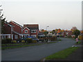
Detached dwellings on Portland Crescent
In my view, these are much more interesting front gardens.
Image: © TCExplorer
Taken: 29 Jun 2023
0.08 miles
2
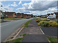
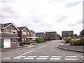
Bungalows on Portland Crescent
Imagine living somewhere where every house looked the same, with no street trees (or front garden trees for that matter) whatsoever, very few shrubs, hardly any flowers, but lots of plain, green grass. Here, ladies and gentleman, is Portland Crescent...
Image: © TCExplorer
Taken: 29 Jun 2023
0.11 miles
3
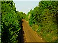
Shrewsbury-Wolverhampton Railway line
Shrewsbury-Wolverhampton Railway line, view from bridge on Belvidere Road
Image: © Andrew Bennett
Taken: 28 Apr 2007
0.14 miles
6
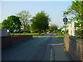
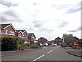
Belvidere Road
Belvidere Road, view north from bridge over railway.
Image: © Andrew Bennett
Taken: 28 Apr 2007
0.18 miles
8

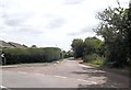
Preston Street junction from Portland Crescent
Image: © John Firth
Taken: 25 Jun 2014
0.23 miles
10
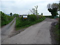
Fork in the lane
The track on the left heads towards Weir Hill Farm and the right fork heads towards the river, carrying the footpath.
Image: © Jeremy Bolwell
Taken: 4 May 2012
0.24 miles