IMAGES TAKEN NEAR TO
Llanio Road, TREGARON, SY25 6UL
Introduction
This page details the photographs taken nearby to Llanio Road, SY25 6UL by members of the Geograph project.
The Geograph project started in 2005 with the aim of publishing, organising and preserving representative images for every square kilometre of Great Britain, Ireland and the Isle of Man.

There are currently over 7.5m images from over14,400 individuals and you can help contribute to the project by visiting https://www.geograph.org.uk
Image Map
Images are licensed for reuse under creativecommons.org/licenses/by-sa/2.0
Notes
- Clicking on the map will re-center to the selected point.
- The higher the marker number, the further away the image location is from the centre of the postcode.
Image Listing (11 Images Found)
Images are licensed for reuse under creativecommons.org/licenses/by-sa/2.0
Image
Details
Distance
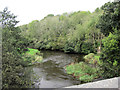
1
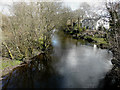
The Afon Teifi from Pont Llanio
The house called Maes-y-derry overlooks the river.
Image: © John Baker
Taken: 25 Mar 2015
0.02 miles
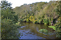
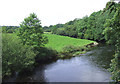
2
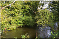
The Afon Teifi above Pont Llanio
Flowing silently under a canopy of trees.
Image: © Nigel Brown
Taken: 17 Oct 2012
0.02 miles
3
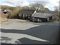
Derelict buildings
These are at the entrance to Llanio railway station, which is disused and derelict.
Image: © John Baker
Taken: 25 Mar 2015
0.04 miles
4
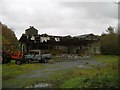
Disused Creamery
The derelict creamery in the north-west of this square was built by the Pumpsaint and District Agricultural Co-operative Society in the 1930s and seems to have operated until the 1970s or possibly early '80s.
Image: © Dan Gregory
Taken: 9 Nov 2006
0.06 miles
5
The Teifi below Pont Llanio
Swollen by recent rain.
Image: © Nigel Brown
Taken: 17 Oct 2012
0.06 miles
6
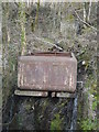
Water tank, Llanio railway station
It was used to replenish the steam engines that once stopped at the station. Should Traws Link Cymru’s campaign to reinstate rail links in west Wales ever come to fruition, the water tank may well be demolished. The proposals are for there to be rail links between Carmarthen and Aberystwyth and between Afon Wen on the Cambrian Coast Line and Bangor to create a rail corridor along the west coast of Wales http://www.trawslinkcymru.org.uk/
Image: © John Baker
Taken: 25 Mar 2015
0.07 miles
7
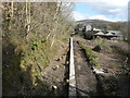
Llanio Station platform
Llanio station platform is over 300 feet long. In the distance is a stone, goods shed that was never connected to the railway. The station was opened in 1871, the creamery opened in 1896 and in 1937 another building was erected, that is now very dilapidated. Passenger traffic ceased to run from 22 February 1965, milk trains continued to run from the sidings until October 1970 when all trains north of Aberaeron Junction were withdrawn but milk trains continued to run to Green Grove Creamery, Felin Fach until September 1973. In 2014, members of Traws Link Cymru were allowed access to the platform and yard area to clear tree and scrub growth (taken from the February 2015 issue of The Grapevine, a free magazine about Lampeter and its environs). Traws Link Cymru is a campaign to reinstate rail links in west Wales. The proposals are for there to be rail links between Carmarthen and Aberystwyth and between Afon Wen on the Cambrian Coast Line and Bangor to create a rail corridor along the west coast of Wales http://www.trawslinkcymru.org.uk/
Image: © John Baker
Taken: 25 Mar 2015
0.07 miles
8
Afon Teifi from Pont Llanio
Looking downstream as the river flows towards Cardigan.
Image: © Stuart Logan
Taken: 6 Oct 2011
0.07 miles
9
The Afon Teifi from Pont Llanio, Ceredigion
A lot of rain has fallen in recent weeks.
Image: © Roger Kidd
Taken: 28 Jul 2007
0.10 miles
10

Field above Pont Llanio
Field beside the A485 above Pont Llanio.
Image: © Philip Halling
Taken: 15 Jul 2021
0.15 miles