IMAGES TAKEN NEAR TO
Llangeitho, TREGARON, SY25 6TT
Introduction
This page details the photographs taken nearby to SY25 6TT by members of the Geograph project.
The Geograph project started in 2005 with the aim of publishing, organising and preserving representative images for every square kilometre of Great Britain, Ireland and the Isle of Man.

There are currently over 7.5m images from over14,400 individuals and you can help contribute to the project by visiting https://www.geograph.org.uk
Image Map
Images are licensed for reuse under creativecommons.org/licenses/by-sa/2.0
Notes
- Clicking on the map will re-center to the selected point.
- The higher the marker number, the further away the image location is from the centre of the postcode.
Image Listing (5 Images Found)
Images are licensed for reuse under creativecommons.org/licenses/by-sa/2.0
Image
Details
Distance
1
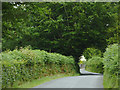
Lane north-east of Llangeitho, Ceredigion
The lane leads towards the head of the Aeron Valley, and the B4578 near Tyncelyn.
Image: © Roger D Kidd
Taken: 19 Jul 2011
0.18 miles
2
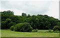
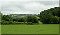
Pasture and woodland by the Afon Aeron near Llangeitho, Ceredigion
The river flows from right to left by the bushes in the middle of the image.
Image: © Roger D Kidd
Taken: 19 Jul 2011
0.18 miles
3
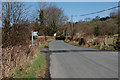
The Llangeitho road near Cwm-coch
The bridleway signposted here heads off right up Cwm-coch.
Image: © Nigel Brown
Taken: 4 Mar 2008
0.21 miles
4
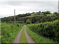
Heol fynediad y Glyn / Glyn access road
Heol fynediad i anhedd-dy o'r enw'r Glyn.
Access road to a property know as y Glyn (trans. the glen).
Image: © Alan Richards
Taken: 12 Jun 2019
0.24 miles
5
Upper Aeron Valley, Ceredigion
The valley widens here north-east of Llangeitho, and contains rich pasture land for many miles.
Image: © Roger D Kidd
Taken: 19 Jul 2011
0.24 miles