IMAGES TAKEN NEAR TO
Llanddewi Brefi, TREGARON, SY25 6NZ
Introduction
This page details the photographs taken nearby to SY25 6NZ by members of the Geograph project.
The Geograph project started in 2005 with the aim of publishing, organising and preserving representative images for every square kilometre of Great Britain, Ireland and the Isle of Man.

There are currently over 7.5m images from over14,400 individuals and you can help contribute to the project by visiting https://www.geograph.org.uk
Image Map
Images are licensed for reuse under creativecommons.org/licenses/by-sa/2.0
Notes
- Clicking on the map will re-center to the selected point.
- The higher the marker number, the further away the image location is from the centre of the postcode.
Image Listing (23 Images Found)
Images are licensed for reuse under creativecommons.org/licenses/by-sa/2.0
Image
Details
Distance
1
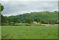
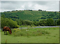
Pasture near Pont Gogoyan, Ceredigion
Looking towards the farm at Cefn-Ilwyn. The zit in the middle of the sky is a hang-glider.
Image: © Roger D Kidd
Taken: 20 Jul 2011
0.16 miles
2
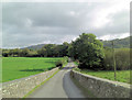
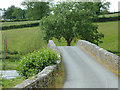
Lane towards Llanddewi-Brefi from Pont Gogoyan
Taken atop the Grade II* listed Pont Gogoyan which was built in the late 18th C. Cadw Building ID: 9921
Image: © Stuart Logan
Taken: 6 Oct 2011
0.18 miles
3
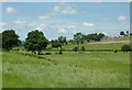
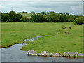
Farmland west of Llanddewi-Brefi, Ceredigion
The Afon Brefi flows from right to left (towards the Afon Teifi) through the low ground crossing the middle of the image. It looks like a bridge has been constructed by the central birch tree, not yet shown on the available satellite images. The farm buildings on the hill are at Garth.
Image: © Roger D Kidd
Taken: 20 Jul 2011
0.19 miles
4
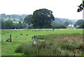
Grazing near Llanddewi-Brefi, Ceredigion
Seen from the B4343 and looking towards the Teifi valley near Pont Gogoyan.
Image: © Roger Kidd
Taken: 23 Jul 2007
0.20 miles
5
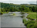
Grazing by the Afon Teifi at Pont Gogoyan, Ceredigion
The river level is above normal because of the three rainy days preceding the day of the image. The hillside marks the western edge of the Elenydd moorlands.
Image: © Roger D Kidd
Taken: 20 Jul 2011
0.20 miles
6
The Afon Teifi from Pont Gogoyan, Ceredigion
Looking downstream, this shows the river following three wet days, during which the lengthy periods of rain were sometimes quite heavy. The hillside on the skyline marks the western edge of the Elenydd moorlands.
Image: © Roger D Kidd
Taken: 20 Jul 2011
0.21 miles
7
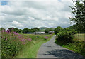
Lane to Llanddewi-Brefi, Ceredigion
The lane crosses the Afon Teifi at Pont Gogoyan, thus providing a link from land west of the river. Ahead is the farm at Garthwen.
Image: © Roger D Kidd
Taken: 20 Jul 2011
0.22 miles
8
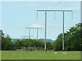
Power lines along the Teifi Valley, Ceredigion
The cables are seen here over the flood plain at Pont Gogoyan, disappearing towards Llanio.
Image: © Roger D Kidd
Taken: 20 Jul 2011
0.22 miles
9
Pasture by the Afon Teifi at Pont Gogoyan, Ceredigion
The river is flowing swiftly following a long wet weekend. A drainage channel flows into the river twenty metres from the bridge.
Image: © Roger D Kidd
Taken: 20 Jul 2011
0.22 miles
10
Pont Gogoyan near Llanddewi-Brefi, Ceredigion
The bridge crosses the Afon Teifi here just over a mile (2 km) from Llanddewi-Brefi. This structure is Grade II* listed, and was built late in the eighteenth century. It is a humped bridge of five rounded arches, about forty metres long and only two and a half metres in width.
Image: © Roger D Kidd
Taken: 20 Jul 2011
0.22 miles