IMAGES TAKEN NEAR TO
TREGARON, SY25 6NW
Introduction
This page details the photographs taken nearby to SY25 6NW by members of the Geograph project.
The Geograph project started in 2005 with the aim of publishing, organising and preserving representative images for every square kilometre of Great Britain, Ireland and the Isle of Man.

There are currently over 7.5m images from over14,400 individuals and you can help contribute to the project by visiting https://www.geograph.org.uk
Image Map
Images are licensed for reuse under creativecommons.org/licenses/by-sa/2.0
Notes
- Clicking on the map will re-center to the selected point.
- The higher the marker number, the further away the image location is from the centre of the postcode.
Image Listing (30 Images Found)
Images are licensed for reuse under creativecommons.org/licenses/by-sa/2.0
Image
Details
Distance
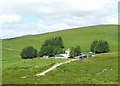
1
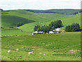
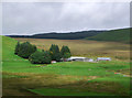
Nantymaen farm, Ceredigion
The northern part of the Cwm Berwyn Plantation is on the skyline.
Image: © Roger D Kidd
Taken: 21 Jul 2008
0.01 miles
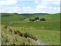
2
Nantymaen farm
Pretty remote, but a well sheltered spot.
Image: © Nigel Brown
Taken: 17 Apr 2008
0.01 miles
3
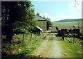
Ffarm Nant y Maen Farm
Agosau at Ffarm Nant y Maen yn 1999 pryd yr ai'r llwybr ceffyl, cyn y dargyfeiriad, drwy'r clos.
Approaching Nant y Maen Farm in 1999 when the bridleway, prior to the diversion, went through the farmyard.
Image: © Alan Richards
Taken: 8 Jan 1999
0.03 miles
4
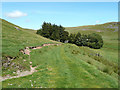
Bridleway towards Nantymaen, Ceredigion
Image: © Roger D Kidd
Taken: 21 Jul 2008
0.03 miles
5
Farm at Nantymaen, Ceredigion
The track climbing left from the coniferous trees is the bridleway to Strata Florida, Pontrhydfendraid and Tregaron.
Image: © Roger D Kidd
Taken: 21 Jul 2008
0.06 miles
6
Elenydd moorland and Nantymaen farm, Ceredigion
Image: © Roger D Kidd
Taken: 21 Jul 2008
0.07 miles
7
Nantymaen farm and Cwm Camddwr in Ceredigion
This is a telephoto assisted image taken looking north towards Nantymaen from the Tregaron to Abergwesyn former drove road.
In the foreground is the Afon Camddwr, which is joined by the greener enclosed grazed area by Nant y Maen. On the skyline, the edge of the Tywi Forest looms.
Image: © Roger D Kidd
Taken: 28 Apr 2010
0.13 miles
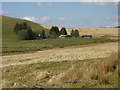
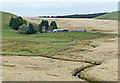
8
Elenydd landscape from Cerrig Maesycawnau, Ceredigion
The northern trees of the Cwm Berwyn Plantation cloaks the skyline. Nantymaen Farm can be seen in the valley of the moorland stream of the same name.
Image: © Roger D Kidd
Taken: 21 Jul 2008
0.13 miles
9
Nantymaen farm in Cwm Camddwr, Ceredigion
The farm is near the head of the Camddwr valley in the Elenydd moorlands. Contrast the September colours here with the July ones of a 2008 image http://www.geograph.org.uk/photo/905534 .
Image: © Roger D Kidd
Taken: 16 Sep 2010
0.15 miles
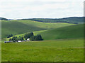
10
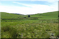
Rough grazing and Blaen Camddwr, Ceredigion
Near Nantymaen Farm (a wide angle image).
Image: © Roger D Kidd
Taken: 21 Jul 2008
0.15 miles