IMAGES TAKEN NEAR TO
Tynreithyn, TREGARON, SY25 6LN
Introduction
This page details the photographs taken nearby to SY25 6LN by members of the Geograph project.
The Geograph project started in 2005 with the aim of publishing, organising and preserving representative images for every square kilometre of Great Britain, Ireland and the Isle of Man.

There are currently over 7.5m images from over14,400 individuals and you can help contribute to the project by visiting https://www.geograph.org.uk
Image Map
Images are licensed for reuse under creativecommons.org/licenses/by-sa/2.0
Notes
- Clicking on the map will re-center to the selected point.
- The higher the marker number, the further away the image location is from the centre of the postcode.
Image Listing (5 Images Found)
Images are licensed for reuse under creativecommons.org/licenses/by-sa/2.0
Image
Details
Distance
1
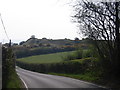
Castell Flemish
Bryngaer ar ochr A485 ger Tyncelyn / Hillfort by the A485 near Tyncelyn
Image: © Ian Medcalf
Taken: 21 Apr 2007
0.13 miles
2
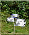
Signpost north-west of Tregaron, Ceredigion
...and no, I wasn't holding the camera on the slant ;-))
Image: © Roger D Kidd
Taken: 14 Aug 2015
0.16 miles
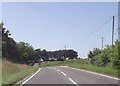
4
The A485 to Aberystwyth, Ceredigion
This is near the Castell Flemish hill fort.
Image: © Roger D Kidd
Taken: 14 Aug 2015
0.17 miles
5
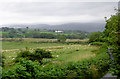
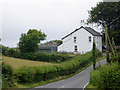
Farmland east of Tyncelyn, Ceredigion
Seen from the A485 road junction near Castell Flemish. The narrow lane in the foreground leads towards Swyddffynnon. The buildings near the middle of the image are at Tynbwlch. The cloud covered moorlands of the Elenydd form the skyline.
Image: © Roger D Kidd
Taken: 14 Aug 2015
0.25 miles