IMAGES TAKEN NEAR TO
TREGARON, SY25 6LG
Introduction
This page details the photographs taken nearby to SY25 6LG by members of the Geograph project.
The Geograph project started in 2005 with the aim of publishing, organising and preserving representative images for every square kilometre of Great Britain, Ireland and the Isle of Man.

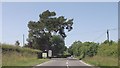
There are currently over 7.5m images from over14,400 individuals and you can help contribute to the project by visiting https://www.geograph.org.uk
Image Map
Images are licensed for reuse under creativecommons.org/licenses/by-sa/2.0
Notes
- Clicking on the map will re-center to the selected point.
- The higher the marker number, the further away the image location is from the centre of the postcode.
Image Listing (41 Images Found)
Images are licensed for reuse under creativecommons.org/licenses/by-sa/2.0
Image
Details
Distance
2
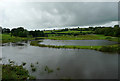
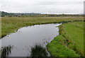
The Afon Teifi north-west of Tregaron, Ceredigion
Seen, after several days of wet weather, from the new (1972) Pont Einon.
Image: © Roger D Kidd
Taken: 21 Jul 2010
0.11 miles
3
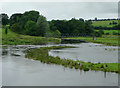
The Afon Teifi north-west of Tregaron, Ceredigion
Seen from the new (1972) Pont Einon and flowing quite high after several days of wet weather.
The footbridge does not carry a public right of way.
This area is at the southern end of a wide part of the valley which contains Cors Caron (The Bog of Tregaron). Satellite images show no sign of tracks to or from it, so it appears almost unused.
Image: © Roger D Kidd
Taken: 21 Jul 2010
0.12 miles
4
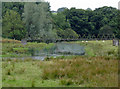
Riverside pasture north-west of Tregaron, Ceredigion
This telephoto assisted image shows the Afon Teifi north of Pen-y-Bont farm, with the footbridge.
Image: © Roger D Kidd
Taken: 14 Aug 2015
0.12 miles
5
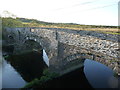
Bridge over the Afon Teifi, Pont Einon
Beside the A485.
Image: © John Lord
Taken: 13 Aug 2011
0.12 miles
6
The Afon Teifi north-west of Tregaron, Ceredigion
Seen from the old bridge by the A485 to Aberystwyth.
Image: © Roger D Kidd
Taken: 14 Aug 2015
0.12 miles
7

Afon Teifi
Afon Teifi and Pen-y-bont farm viewed from Pont Einon.
Image: © Philip Halling
Taken: 15 Jul 2021
0.13 miles
8

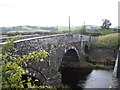
Pont Einon
The old Pont Einon was built in 1805 and replaced by a parallel bridge in 1972. The bridge crosses Afon Teifi.
Image: © Philip Halling
Taken: 15 Jul 2021
0.13 miles
9
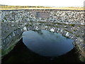
Part of the old bridge at Pont Einon
The plaque was installed at the opening of the new bridge, a wider two lane road bridge in 1972.
Image: © Jeremy Bolwell
Taken: 16 May 2012
0.13 miles
10
Yr Hen Bont, Pont Einon
The old bridge dates to 1805 and was replaced by a modern road bridge only in 1972.
Image: © Jeremy Bolwell
Taken: 16 May 2012
0.13 miles