IMAGES TAKEN NEAR TO
Glangro, TREGARON, SY25 6JY
Introduction
This page details the photographs taken nearby to Glangro, SY25 6JY by members of the Geograph project.
The Geograph project started in 2005 with the aim of publishing, organising and preserving representative images for every square kilometre of Great Britain, Ireland and the Isle of Man.

There are currently over 7.5m images from over14,400 individuals and you can help contribute to the project by visiting https://www.geograph.org.uk
Image Map
Images are licensed for reuse under creativecommons.org/licenses/by-sa/2.0
Notes
- Clicking on the map will re-center to the selected point.
- The higher the marker number, the further away the image location is from the centre of the postcode.
Image Listing (130 Images Found)
Images are licensed for reuse under creativecommons.org/licenses/by-sa/2.0
Image
Details
Distance
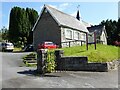
1
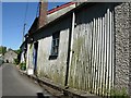
A tin (corrugated iron) bungalow on the banks of Afon Brennig, Tregaron
One of several unusual cottages along the river bank of Afon Brennig, just off the High Street.
Image: © Skinscribe
Taken: 10 Jun 2008
0.02 miles
2
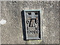
Ordnance Survey Flush Bracket S7099
This can be found on the wall of Tregaron Public Library.
For more detail see : http://www.bench-marks.org.uk/bm20666
Image: © Peter Wood
Taken: 18 Apr 2015
0.05 miles
3
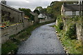
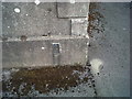
Afon Brennig, Tregaron
Taken from the small bridge between Chapel Street and High Street, it's evident that this innocuous looking stream is not always so! The bridge is fitted with flood defences at either end and the stream banks are fortified with high walls.
Image: © Stuart Logan
Taken: 6 Oct 2011
0.05 miles
4
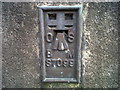
OSBM Flush Bracket S7099 - Tregaron County School
Ordnance Survey Benchmark (OSBM) used for levelling height above Ordnance Datum (OD).
Height (1971): 171.3630m OD (Newlyn). Mark verified by the Ordnance Survey in 1971. Description: FL BR S7099 SCH SE SIDE RD W ANG NW FACE. 0.3m above ground. 2nd Order BM.
The bracket was used on the Lampeter to Devil's Bridge secondary line of the Second Geodetic Levelling of England & Wales in 1952. It was levelled with a height of 526.326' above OD (Newlyn). Description: Flush Bracket on W face, SW angle of County School, E side of road. Abstract S 1: http://discovery.nationalarchives.gov.uk/details/r/C11225255 [OS 54/633]
Context: Image
Image: © N Scott
Taken: 18 Mar 2015
0.05 miles
5
OSBM Flush Bracket S7099 - Tregaron County School
Ordnance Survey Benchmark (OSBM) used for levelling height above Ordnance Datum (OD).
Height (1971): 171.3630m OD (Newlyn). Mark verified by the Ordnance Survey in 1971. Description: FL BR S7099 SCH SE SIDE RD W ANG NW FACE. 0.3m above ground. 2nd Order BM.
The bracket was used on the Lampeter to Devil's Bridge secondary line of the Second Geodetic Levelling of England & Wales in 1952. It was levelled with a height of 526.326' above OD (Newlyn). Description: Flush Bracket on W face, SW angle of County School, E side of road. Abstract S 1: http://discovery.nationalarchives.gov.uk/details/r/C11225255 [OS 54/633]
Close-up: Image
Image: © N Scott
Taken: 18 Mar 2015
0.05 miles
6
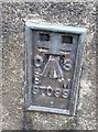
Ordnance Survey Flush Bracket (S7099)
This OS Flush Bracket can be found on the NW face of the old school. It marks a point 171.363m above mean sea level.
Image: © Adrian Dust
Taken: 27 Aug 2017
0.05 miles
7
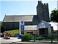
Jenkins' Garage, Tregaron
A typical country garage squeezed between the bridge over the Afon Groes and the parish church on the B4343.
Image: © Stephen McKay
Taken: 24 Jul 2006
0.06 miles
8
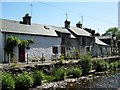
An unusual range of terraced cottages on the banks of Afon Brennig, Tregaron
Just off High Street, Tregaron, the river bank is lined with a short terrace of highly individual cottages, including a tin (corrugated iron) bungalow.
Image: © Skinscribe
Taken: 10 Jun 2008
0.07 miles
9
The Red Kite Centre and Museum
The Red Kite Centre and Museum in Tregaron.
Image: © Philip Halling
Taken: 15 Jul 2021
0.07 miles
10
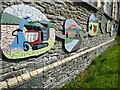
Pictures on the front of a building
Pictures on the front the Red Kite Centre and Museum in Tregaron.
Image: © Philip Halling
Taken: 15 Jul 2021
0.07 miles