IMAGES TAKEN NEAR TO
Maesyrawel, TREGARON, SY25 6HJ
Introduction
This page details the photographs taken nearby to Maesyrawel, SY25 6HJ by members of the Geograph project.
The Geograph project started in 2005 with the aim of publishing, organising and preserving representative images for every square kilometre of Great Britain, Ireland and the Isle of Man.

There are currently over 7.5m images from over14,400 individuals and you can help contribute to the project by visiting https://www.geograph.org.uk
Image Map
Images are licensed for reuse under creativecommons.org/licenses/by-sa/2.0
Notes
- Clicking on the map will re-center to the selected point.
- The higher the marker number, the further away the image location is from the centre of the postcode.
Image Listing (126 Images Found)
Images are licensed for reuse under creativecommons.org/licenses/by-sa/2.0
Image
Details
Distance
1
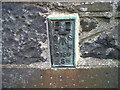
OSBM Flush Bracket S0759 - Tregaron, Bryn Caron
Ordnance Survey Benchmark (OSBM) used for levelling height above Ordnance Datum (OD).
Height (1971): 170.0780m OD (Newlyn). Mark verified by the Ordnance Survey in 1971. Description: FL BR S0759 BRYNCARON SE SIDE RD N ANG NW FACE. 0.9m above ground. 2nd Order BM.
The bracket was used on the Lampeter to Devil's Bridge secondary line of the Second Geodetic Levelling of England & Wales in 1952. It was levelled with a height of 558.109' above OD (Newlyn). Description: Flush Bracket on NW angle of house, SE side of road, at junction of roads. Abstract S 1: http://discovery.nationalarchives.gov.uk/details/r/C11225255 [OS 54/633]
Context: Image
Image: © N Scott
Taken: 24 Oct 2014
0.04 miles
2
OSBM Flush Bracket S0759 - Tregaron, Bryn Caron
Ordnance Survey Benchmark (OSBM) used for levelling height above Ordnance Datum (OD).
Height (1971): 170.0780m OD (Newlyn). Mark verified by the Ordnance Survey in 1971. Description: FL BR S0759 BRYNCARON SE SIDE RD N ANG NW FACE. 0.9m above ground. 2nd Order BM.
The bracket was used on the Lampeter to Devil's Bridge secondary line of the Second Geodetic Levelling of England & Wales in 1952. It was levelled with a height of 558.109' above OD (Newlyn). Description: Flush Bracket on NW angle of house, SE side of road, at junction of roads. Abstract S 1: http://discovery.nationalarchives.gov.uk/details/r/C11225255 [OS 54/633]
Close-up: Image
Image: © N Scott
Taken: 24 Oct 2014
0.04 miles
3
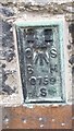
Ordnance Survey Flush Bracket (S0759)
This OS Flush Bracket can be found on the NW face of Bryncaron. It marks a point 170.078m above mean sea level.
Image: © Adrian Dust
Taken: 27 Aug 2017
0.04 miles
4
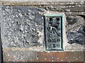
Ordnance Survey Flush Bracket S0759
This can be found on the wall of a private dwelling in Tregaron.
For more detail see : http://www.bench-marks.org.uk/bm20533
Image: © Peter Wood
Taken: 18 Apr 2015
0.04 miles
5
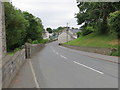
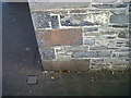
Pontrhydfendigaid Road (B4343) in Tregaron
Looking south-westward.
Image: © Peter Wood
Taken: 5 Jun 2018
0.05 miles
6
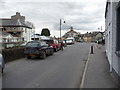
Street scene in Tregaron
Two farmers chat and Lloyds Bank is under scaffolding, the church tower peeps out and I wander by invisible, transient, temporary, the human equivalent of tumbleweed.
Image: © Jeremy Bolwell
Taken: 22 Mar 2011
0.05 miles
7
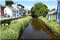
Afon Brennig in Tregaron
Afon Brennig a tributary of the Teifi viewed from the bridge in Tregaron.
Image: © Philip Halling
Taken: 15 Jul 2021
0.07 miles
8
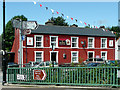
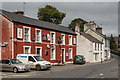
Y Llew Coch at Tregaron, Ceredigion
The Red Lion public house seen from across the bridge over the Afon Brennig.
Image: © Roger D Kidd
Taken: 15 Jul 2009
0.07 miles
9
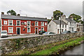
Y Llew Coch
Pub overlooking Afon Brennig.
Image: © Ian Capper
Taken: 6 Sep 2014
0.07 miles
10
Y Llew Coch
Pub overlooking Afon Brennig.
Image: © Ian Capper
Taken: 6 Sep 2014
0.07 miles