IMAGES TAKEN NEAR TO
Pontrhydygroes, YSTRAD MEURIG, SY25 6DQ
Introduction
This page details the photographs taken nearby to SY25 6DQ by members of the Geograph project.
The Geograph project started in 2005 with the aim of publishing, organising and preserving representative images for every square kilometre of Great Britain, Ireland and the Isle of Man.

There are currently over 7.5m images from over14,400 individuals and you can help contribute to the project by visiting https://www.geograph.org.uk
Image Map
Images are licensed for reuse under creativecommons.org/licenses/by-sa/2.0
Notes
- Clicking on the map will re-center to the selected point.
- The higher the marker number, the further away the image location is from the centre of the postcode.
Image Listing (52 Images Found)
Images are licensed for reuse under creativecommons.org/licenses/by-sa/2.0
Image
Details
Distance
1
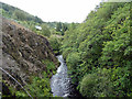
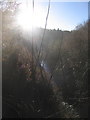
Afon Ystwyth
Looking downstream from Pont-y-mwynwyr [footbridge], Pont-rhyd-y-groes.
Image: © John Lucas
Taken: 19 Aug 2019
0.04 miles
2
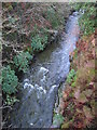
Ystwyth gorge upstream of the Miners' Bridge, Pont-rhyd-y-groes
The gorge lies immediately behind a row of miners' cottages on the main road through Pont-rhyd-y-groes. The footbridge was built in the early naughties to replace an older bridge which used to give the miners access to the lead mines on the north side of the gorge a little downstream.
For a similar view from December 2008, see http://www.geograph.org.uk/photo/1082210 .
Image: © Rudi Winter
Taken: 14 Jan 2012
0.05 miles
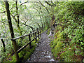
3
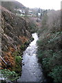
Ystwyth gorge
Looking downstream from the Miners' Bridge, a footbridge in Pont-rhyd-y-groes.
For a similar view in December 2008, see http://www.geograph.org.uk/photo/1082235 .
Image: © Rudi Winter
Taken: 14 Jan 2012
0.05 miles
4
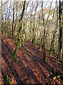
Oak wood on the north side of Ystwyth gorge
A faint track comes up from the Miners' Bridge. It links the Pontrhydygroes with the main forest road in Coed Maenarthur forestry.
Image: © Rudi Winter
Taken: 7 Dec 2008
0.05 miles
5
Ystwyth gorge
This view into the low December sun follows the course of the Ystwyth gorge downstream from the Miners' Bridge at Pontrhydygroes.
Image: © Rudi Winter
Taken: 7 Dec 2008
0.05 miles
6
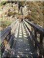
Miners Bridge, Pont-rhyd-y-groes
This bridge replaces a bridge once used by workers going to the lead mines. It now makes walks in the forest more practical by crossing the River Ystwyth near the village. Many walks are way-marked.
Image: © Angella Streluk
Taken: Unknown
0.05 miles
7
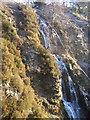
Waterfall by the side of Miners' Bridge, Pontrhydygroes
The section of the cascade shown is about 15m high. It continues further down towards the Afon Ystwyth. The picture was taken from the footbridge in the gorge.
Image: © Rudi Winter
Taken: 7 Dec 2008
0.05 miles
8
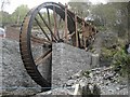
Welsh Waterwheel at Pontrhydygroes
This wheel is currently under construction. It is located just below Lisburne Motors on the side of the road. When visiting this location it is also possible to visit the newly rebuilt Miners' Bridge or the popular Miners' Arms public house nearby.
Image: © Andrew Heath
Taken: 19 Oct 2008
0.05 miles
10
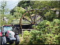
Overshot watermill, Lisburne silver/lead mines, Pont-rhyd-y-groes
This 24' wheel stands on the site of an original 26' wheel constructed in the 1850s to drive ore crushing stamps. It continues to turn, fed by a mile long drainage level in the mine. The Lisburne mine complex was one of the most productive in the Ceredigion area, employing over 400 workers in the 1870s but had closed by 1913 in the face of cheaper imports. The death-knell of the British lead mining industry was sounded after the First World War when the government released its no longer needed stockpiles.
Image: © John Lucas
Taken: 19 Aug 2019
0.06 miles