IMAGES TAKEN NEAR TO
Swyddffynnon, YSTRAD MEURIG, SY25 6AL
Introduction
This page details the photographs taken nearby to SY25 6AL by members of the Geograph project.
The Geograph project started in 2005 with the aim of publishing, organising and preserving representative images for every square kilometre of Great Britain, Ireland and the Isle of Man.

There are currently over 7.5m images from over14,400 individuals and you can help contribute to the project by visiting https://www.geograph.org.uk
Image Map
Images are licensed for reuse under creativecommons.org/licenses/by-sa/2.0
Notes
- Clicking on the map will re-center to the selected point.
- The higher the marker number, the further away the image location is from the centre of the postcode.
Image Listing (16 Images Found)
Images are licensed for reuse under creativecommons.org/licenses/by-sa/2.0
Image
Details
Distance
1
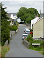
Main Street in Swyddffynnon, Ceredigion
The lane continues towards Ystradmeurig.
Image: © Roger D Kidd
Taken: 17 Aug 2015
0.04 miles
2
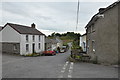
Swyddffynnon as seen from its central junction
Image: © Brenda Coles
Taken: 16 Aug 2012
0.06 miles
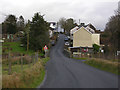
3
Entering Swyddffynnon from the west, Ceredigion
The bridge crosses the Cammdwr Fach.
Image: © Roger D Kidd
Taken: 17 Aug 2015
0.06 miles
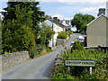
4
Swyddffynnon
The small village of Swyddffynnon is at the centre of the scattered farming communities which lie to the north and west of the Cors Caron (Tregaron Bog). Being on raised ground it is drier than much of the land around here; its name comes from the spring sited here.
Image: © Nigel Brown
Taken: 10 Jan 2008
0.07 miles
5
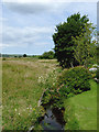
The Camddwr Fach at Swyddffynnon, Ceredigion
Looking upstream. The stream joins the Afo Teifi about a kilometre behind the camera.
Image: © Roger D Kidd
Taken: 17 Aug 2015
0.07 miles
6
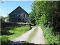
Track and former Welsh Baptist Chapel in Swyddffynnon
Viewed from the east. The Memorial stone indicates that the chapel was originally built in 1824 but subsequently re-built in 1859. It is now a private dwelling.
Image: © Peter Wood
Taken: 7 Jun 2018
0.11 miles
7
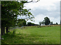
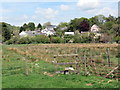
Pasture near Swyddffynnon, Ceredigion
A public footpath crossing fields towards Fullbrook Mill crosses this field by the fence.
Image: © Roger D Kidd
Taken: 17 Aug 2015
0.12 miles
8
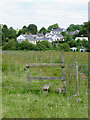
Stile near Swyddffynnon, Ceredigion
A public footpath across fields from Fullbrook Mill to Swyddffynnon is shown on maps. Some sections are overgrown, and some are no longer in use.
Image: © Roger D Kidd
Taken: 17 Aug 2015
0.13 miles
9
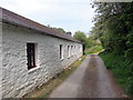
Hen fythynnod yn Swyddffynnon / Former cottages in Swyddffynnon
Anhedd-dy sy'n yn edrych ei fod gynt yn rhes o fythynnod.
A property which look as if it was once arrow of cottages.
Image: © Alan Richards
Taken: 22 May 2019
0.14 miles
10
Llwybr Swyddffynnon / Swyddffynnon Path
Llwybr yn agosau at bentre Swyddffynnon.
A public footpath approaching the village of Swyddffynnon (trans. district of the well).
Image: © Alan Richards
Taken: 22 May 2019
0.17 miles