IMAGES TAKEN NEAR TO
BORTH, SY24 5HY
Introduction
This page details the photographs taken nearby to SY24 5HY by members of the Geograph project.
The Geograph project started in 2005 with the aim of publishing, organising and preserving representative images for every square kilometre of Great Britain, Ireland and the Isle of Man.

There are currently over 7.5m images from over14,400 individuals and you can help contribute to the project by visiting https://www.geograph.org.uk
Image Map
Images are licensed for reuse under creativecommons.org/licenses/by-sa/2.0
Notes
- Clicking on the map will re-center to the selected point.
- The higher the marker number, the further away the image location is from the centre of the postcode.
Image Listing (238 Images Found)
Images are licensed for reuse under creativecommons.org/licenses/by-sa/2.0
Image
Details
Distance
1

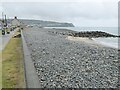
Three houses in Borth
Properties facing west across the pebble beach towards Ireland.
The grey of the sky matches the colour of the beach.
Image: © Jonathan Billinger
Taken: 5 Jul 2012
0.01 miles
2
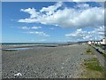
Shingle beach at Borth
View southwards along the shingle beach at Borth.
Image: © Philip Halling
Taken: 23 Jun 2021
0.03 miles
3
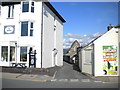
Back lane to church, Borth
Little more than an alleyway squeezed between two seaside essentials: a bed & breakfast, and an amusement arcade.
Image: © Richard Vince
Taken: 14 Aug 2014
0.03 miles
5
View north on Borth Beach
On a bright but cold and windy day in late April. Improvements to the sea defences carried out in 2012 mean the top of the beach is currently level with the road and accessing the sandy beach is hard going.
Note the dead seagull on the left - close-up here http://www.geograph.org.uk/photo/3477493 .
Image: © Penny Mayes
Taken: 27 Apr 2013
0.03 miles
6
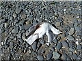
Dead gull on Borth Beach
Not a common sight so I'm puzzled as to how it died - perhaps local kids taking potshots?
Image: © Penny Mayes
Taken: 27 Apr 2013
0.03 miles
7
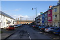
Cambrian Terrace, Borth
This is the road leading from High Street to the railway station.
Image: © Bill Boaden
Taken: 26 Feb 2011
0.03 miles
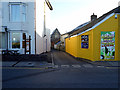
8
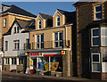
The Spar, Borth
A major convenience for the inhabitants.
Image: © Nigel Brown
Taken: 9 Jan 2010
0.03 miles
9
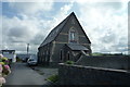
Former Chapel (Borth)
This chapel is now converted into residential use. Viewed from the path/lane that leads up to St. Matthew's Church.
Image: © Fabian Musto
Taken: 25 Aug 2018
0.03 miles
10
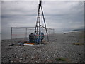
Boring at Borth
A sign attached to the sea wall advises that Ceredigion County Council has commissioned a series of trial borings along the top of the beach to sample ... whatever is underneath, presumably. It may possibly have something to do with the proposed renewal of the sea defences.
Image: © Chris Denny
Taken: 1 May 2010
0.04 miles