IMAGES TAKEN NEAR TO
TALYBONT, SY24 5HL
Introduction
This page details the photographs taken nearby to SY24 5HL by members of the Geograph project.
The Geograph project started in 2005 with the aim of publishing, organising and preserving representative images for every square kilometre of Great Britain, Ireland and the Isle of Man.

There are currently over 7.5m images from over14,400 individuals and you can help contribute to the project by visiting https://www.geograph.org.uk
Image Map
Images are licensed for reuse under creativecommons.org/licenses/by-sa/2.0
Notes
- Clicking on the map will re-center to the selected point.
- The higher the marker number, the further away the image location is from the centre of the postcode.
Image Listing (3 Images Found)
Images are licensed for reuse under creativecommons.org/licenses/by-sa/2.0
Image
Details
Distance
1
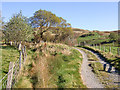
Track to Nant-y-nod
Nant-y-nod is hidden in the trees on the left. The hills in the background are Ffridd Newydd.
Image: © Marcus Byron
Taken: 23 Oct 2007
0.09 miles
2
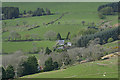
Nant-y-n?d farm
With the roofs of Rhyd-yr-onen farm just visible down on the left.
Image: © Nigel Brown
Taken: 15 Apr 2017
0.13 miles
3
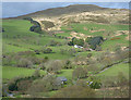
View towards Moel y Llyn
Looking over the roof of the one-time chapel in Cwm Ceulan to Nant-y-nôd farm, with Moel y Llyn rising behind.
Image: © Nigel Brown
Taken: 15 Apr 2017
0.20 miles