IMAGES TAKEN NEAR TO
Birkenhead Street, TALYBONT, SY24 5HB
Introduction
This page details the photographs taken nearby to Birkenhead Street, SY24 5HB by members of the Geograph project.
The Geograph project started in 2005 with the aim of publishing, organising and preserving representative images for every square kilometre of Great Britain, Ireland and the Isle of Man.

There are currently over 7.5m images from over14,400 individuals and you can help contribute to the project by visiting https://www.geograph.org.uk
Image Map
Images are licensed for reuse under creativecommons.org/licenses/by-sa/2.0
Notes
- Clicking on the map will re-center to the selected point.
- The higher the marker number, the further away the image location is from the centre of the postcode.
Image Listing (71 Images Found)
Images are licensed for reuse under creativecommons.org/licenses/by-sa/2.0
Image
Details
Distance
2

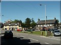
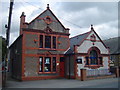
Tal-y-bont Main Street
Looking north along the A487.
Image: © Jonathan Billinger
Taken: 5 Jul 2012
0.03 miles
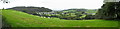
3
Talybont, Ceredigion
'Y Patsien Glas', the village green in the centre of Talybont, with the two Lions, the Black and the White.
Image: © Nigel Callaghan
Taken: 30 May 2005
0.04 miles
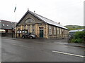
5
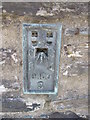
Ordnance Survey Flush Bracket (S0460)
This OS Flush Bracket can be found on a house to the west of the road, almost opposite the Police Station. It marks a point 61.513m above mean sea level.
Image: © Adrian Dust
Taken: 13 Jun 2014
0.05 miles
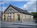
7
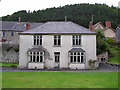
Mine Manager's House
The main adit of the Tal y Bont Mine originally came out to the right of the building.
Image: © Chris Andrews
Taken: 16 Aug 2009
0.05 miles
10
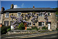
Cottages in Talybont
Wisteria covered cottages on the main road through the village.
Image: © Helen Wilkinson
Taken: 17 May 2009
0.06 miles