IMAGES TAKEN NEAR TO
TALYBONT, SY24 5EQ
Introduction
This page details the photographs taken nearby to SY24 5EQ by members of the Geograph project.
The Geograph project started in 2005 with the aim of publishing, organising and preserving representative images for every square kilometre of Great Britain, Ireland and the Isle of Man.

There are currently over 7.5m images from over14,400 individuals and you can help contribute to the project by visiting https://www.geograph.org.uk
Image Map
Images are licensed for reuse under creativecommons.org/licenses/by-sa/2.0
Notes
- Clicking on the map will re-center to the selected point.
- The higher the marker number, the further away the image location is from the centre of the postcode.
Image Listing (7 Images Found)
Images are licensed for reuse under creativecommons.org/licenses/by-sa/2.0
Image
Details
Distance
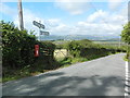
2
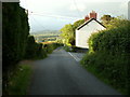
Road junction, Staylittle
The junction between Staylittle and Pentre-bach, back road to Talybont on the right. Looking north.
Image: © Nigel Callaghan
Taken: 3 Jun 2005
0.05 miles
3
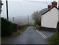
Road junction, Staylittle
The main route is the back road from Taliesin to Dôl-y-bont, while the road on the right is a short cut into Talybont. The name Staylittle is a literal English translation of Pentre-bach, "pentre" meaning a place of habitation (hamlet, and so on), a place where people "stay". Here the houses of Staylittle behind the camera are mainly of recent construction, while the cottages of Pentre-bach down the hill ahead are much older, and at one time housed local miners.
Image: © Nigel Brown
Taken: 18 Dec 2008
0.18 miles
4
Junction on the road between Taliesin and Dol-y-bont
Image: © John Lord
Taken: 16 Aug 2018
0.18 miles
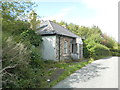
5
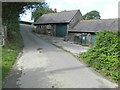
Llwynawel, Tal-y-bont
Natural Resources Wales workshop.
Image: © John Lord
Taken: 16 Aug 2018
0.20 miles
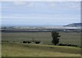
6
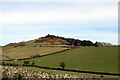
Banc Tŷ-hen
Viewed from near Alltgoch. The hill stands a between the hamlet of Staylittle and Tal-y-bont and has the remains of past mining activity including levels and shafts.
Image: © John Lucas
Taken: 23 Apr 2021
0.20 miles