IMAGES TAKEN NEAR TO
TALYBONT, SY24 5EE
Introduction
This page details the photographs taken nearby to SY24 5EE by members of the Geograph project.
The Geograph project started in 2005 with the aim of publishing, organising and preserving representative images for every square kilometre of Great Britain, Ireland and the Isle of Man.

There are currently over 7.5m images from over14,400 individuals and you can help contribute to the project by visiting https://www.geograph.org.uk
Image Map
Images are licensed for reuse under creativecommons.org/licenses/by-sa/2.0
Notes
- Clicking on the map will re-center to the selected point.
- The higher the marker number, the further away the image location is from the centre of the postcode.
Image Listing (4 Images Found)
Images are licensed for reuse under creativecommons.org/licenses/by-sa/2.0
Image
Details
Distance
1
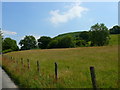
Tal-y-Bont
Caeau ger Tal-y-Bont / Fields near Talybont.
Image: © Ian Medcalf
Taken: 26 Jun 2010
0.12 miles
2
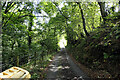
Minor road leading to Bwlch Garw
Also forms part of the Borth to Devil's Bridge Trail.
Image: © John Lucas
Taken: 29 Sep 2021
0.14 miles
3
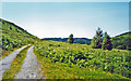
Course of former Plynlimon & Hafan Tramway, near Tal-y-Bont
View westward down the valley of the Afon Leri towards Tal-y-Bont village. The tramway, which was built in 1897 to transport minerals from the lead-mines at Bwlch Glas to the Cambrian Railway at Llandre, lasted only TWO years, but nevertheless carried passengers from Llandre as far as Tal-y-Bont! The mountain up to the left is Braich Garw. (This must be one of the most obscure 'Sites of a Railway Station').
Image: © Ben Brooksbank
Taken: 24 Jun 2004
0.17 miles
4
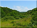
Braich Garw
Coedwigoedd yng nghwm Leri / Woodlands in Cwm Leri.
Image: © Ian Medcalf
Taken: 26 Jun 2010
0.20 miles