IMAGES TAKEN NEAR TO
LLANON, SY23 5HE
Introduction
This page details the photographs taken nearby to SY23 5HE by members of the Geograph project.
The Geograph project started in 2005 with the aim of publishing, organising and preserving representative images for every square kilometre of Great Britain, Ireland and the Isle of Man.

There are currently over 7.5m images from over14,400 individuals and you can help contribute to the project by visiting https://www.geograph.org.uk
Image Map
Images are licensed for reuse under creativecommons.org/licenses/by-sa/2.0
Notes
- Clicking on the map will re-center to the selected point.
- The higher the marker number, the further away the image location is from the centre of the postcode.
Image Listing (38 Images Found)
Images are licensed for reuse under creativecommons.org/licenses/by-sa/2.0
Image
Details
Distance
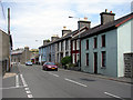
1
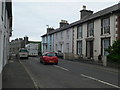
Stryd Fawr, Llanon
The main A487 passing through the village of Llanon.
Image: © Eirian Evans
Taken: 14 May 2011
0.01 miles
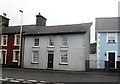
3
Belmont, Bridge Street
Belmont is now a private house but was in the past of Llanon, the local post office
Image: © Harry Hayfield
Taken: 29 Mar 2011
0.02 miles
4
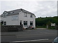
W B Evans, Butchers, Llanon
Local family butcher on the main street in Llanon. This butcher supplies meat from his own farm, Pentre Farm and also sells online.
Image: © Eirian Evans
Taken: 14 May 2011
0.03 miles
5
Stryd Fawr (High Street), Llanon
Looking north-east in the Aberystwyth direction. This is the main A487 road through the village and can become very congested at busy times.
Image: © John Lucas
Taken: 27 Jul 2006
0.03 miles
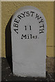
7
11 miles to Aberystwyth
Milestone in the village of Llanon
Image: © Eirian Evans
Taken: 14 May 2011
0.05 miles
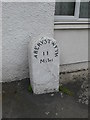
8
Old Milestone by the A487, Llanon, Llansantffraid Parish
Aberystwyth tombstone by the A487, in parish of Llansantffraid (Ceredigion District), by "Mile End", Llanon, Stryd Fawr, on pavement back to wall.
Inscription read:-
ABERYSTWYTH
11
MILES
Grade II listed by Cadw. Reference Number: 17905
https://cadwpublic-api.azurewebsites.net/reports/listedbuilding/FullReport?lang=&id=17905
Surveyed
Milestone Society National ID: CRD_AYCA11
Image: © Milestone Society
Taken: Unknown
0.05 miles
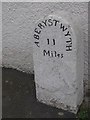
9
Aberystwyth 11 miles
Compare this image with one taken in 2011 when the wall was white: Image
Image: © Stephen McKay
Taken: 16 Jul 2015
0.05 miles
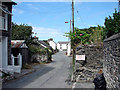
10
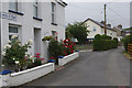
Heol-y-Dwr, Llanon
Heol-y-Dwr (Water Road) leads off the A487 in Llanon village.
Image: © Stephen McKay
Taken: 13 Jul 2015
0.08 miles