IMAGES TAKEN NEAR TO
LLANRHYSTUD, SY23 5AG
Introduction
This page details the photographs taken nearby to SY23 5AG by members of the Geograph project.
The Geograph project started in 2005 with the aim of publishing, organising and preserving representative images for every square kilometre of Great Britain, Ireland and the Isle of Man.

There are currently over 7.5m images from over14,400 individuals and you can help contribute to the project by visiting https://www.geograph.org.uk
Image Map
Images are licensed for reuse under creativecommons.org/licenses/by-sa/2.0
Notes
- Clicking on the map will re-center to the selected point.
- The higher the marker number, the further away the image location is from the centre of the postcode.
Image Listing (7 Images Found)
Images are licensed for reuse under creativecommons.org/licenses/by-sa/2.0
Image
Details
Distance
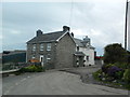
1
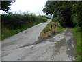
Track to Pen-y-cwm-uchaf farm
Farmhouse roof visible beyond the brow of the track.
Image: © John Lord
Taken: 17 Aug 2013
0.05 miles
5
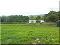
The llyn of Maesllyn?
Lake not shown on OS map, but clearly visible on Bing Maps Bird's Eye.
Image: © John Lord
Taken: 17 Aug 2013
0.20 miles
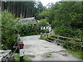
7
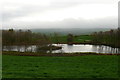
Llyn ger Maesllyn / Lake near Maesllyn
Llyn ger Maesllyn gyda Mynydd Bach yn y cefndir/ Lake near Maesllyn with Mynydd Bach in the background.
Image: © Ian Medcalf
Taken: 5 Apr 2014
0.21 miles