IMAGES TAKEN NEAR TO
SY23 4NH
Introduction
This page details the photographs taken nearby to SY23 4NH by members of the Geograph project.
The Geograph project started in 2005 with the aim of publishing, organising and preserving representative images for every square kilometre of Great Britain, Ireland and the Isle of Man.

There are currently over 7.5m images from over14,400 individuals and you can help contribute to the project by visiting https://www.geograph.org.uk
Image Map
Images are licensed for reuse under creativecommons.org/licenses/by-sa/2.0
Notes
- Clicking on the map will re-center to the selected point.
- The higher the marker number, the further away the image location is from the centre of the postcode.
Image Listing (106 Images Found)
Images are licensed for reuse under creativecommons.org/licenses/by-sa/2.0
Image
Details
Distance
1
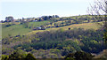
Pisgah
Viewed from the Cwmrheidol road out of Capel Bangor.
Image: © John Lucas
Taken: 21 Apr 2020
0.09 miles
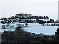
2
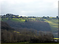
Pisgah receives some welcome winter sunshine
Image: © John Lucas
Taken: 5 Feb 2018
0.11 miles
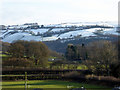
4
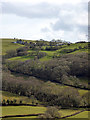
A pleasant day in Cwm Rheidol
Looking towards Blwlch-heble, just along from Pisgah. Viewed from Pant Da Wood. Temperature an almost balmy 14°C!
Image: © John Lucas
Taken: 15 Mar 2018
0.12 miles
5
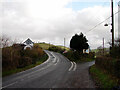
Road junction in Pisgah
The A4120 road to Devil's Bridge bears to the left. The minor road on the right is a no through road to Cennant.
Image: © John Lucas
Taken: 27 Nov 2006
0.12 miles
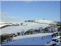
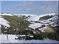
6
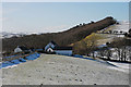
Snow laying at Pisgah
The north facing hillside at Pisagah is slow to lose its snow cover.
Image: © John Lucas
Taken: 1 Feb 2019
0.13 miles
7
Pisgah viewed from Pant Da Nature Reserve
Image: © John Lucas
Taken: 17 Apr 2012
0.13 miles
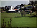
8
East end of Pisgah
The east end of this well spaced community lies in a dip, actually a col between the Rheidol and Gledryd valleys; the latter can be seen ahead. An ancient road to the east, now a bridleway, climbs along the valley side to the right, another old route proceeds up the valley, but today the main road, seen bottom left, sweeps left to contour high above the Rheidol valley.
Image: © Nigel Brown
Taken: 4 Mar 2006
0.13 miles
9
Capel Pisgah, Bwlch Heble
The chapel after which Pisgah takes its name, situated above the distinct col of Bwlch Heble which lies between the Gledryd and Rheidol valleys. The chapel is now a private house.
Image: © Nigel Brown
Taken: 6 Feb 2009
0.13 miles
10
Pisgah viewed from Cwm Rheidol
The small hamlet is viewed here from the Gamlyn footbridge beside Afon Rheidol.
Image: © John Lucas
Taken: 12 Dec 2017
0.13 miles