IMAGES TAKEN NEAR TO
The Terrace, ABERYSTWYTH, SY23 4LJ
Introduction
This page details the photographs taken nearby to The Terrace, SY23 4LJ by members of the Geograph project.
The Geograph project started in 2005 with the aim of publishing, organising and preserving representative images for every square kilometre of Great Britain, Ireland and the Isle of Man.

There are currently over 7.5m images from over14,400 individuals and you can help contribute to the project by visiting https://www.geograph.org.uk
Image Map
Images are licensed for reuse under creativecommons.org/licenses/by-sa/2.0
Notes
- Clicking on the map will re-center to the selected point.
- The higher the marker number, the further away the image location is from the centre of the postcode.
Image Listing (6 Images Found)
Images are licensed for reuse under creativecommons.org/licenses/by-sa/2.0
Image
Details
Distance
1
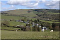
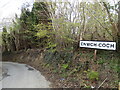
Cnwch-coch
The entire village is in view here from the hill above. At the left end of the branch road can be seen Capel Carmel, the Methodist chapel, next to the cemetery. On the left of the picture can be seen Troed-rhiw-rydis farm. The farm in the valley of the Afon Magwr below is Cwmnewidion Isaf.
Image: © Rudi Winter
Taken: 6 May 2021
0.09 miles
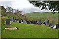
3
Sheep pasture at Cnwch Coch
A flock of sheep occupy a long narrow field speckled with trees on the south bank of the local stream, which is a tributary of the Nant Magwr.
Image: © Rudi Winter
Taken: 1 Jan 2014
0.14 miles
4
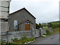
Wayside chapel
A small 19th century chapel beside the road leading to Cnwch Coch
Image: © Eirian Evans
Taken: 22 May 2015
0.16 miles
5
Entrance to Cnwch-coch
There is a steep triple bend in the road above the village.
Image: © Rudi Winter
Taken: 6 May 2021
0.21 miles
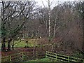
6
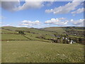
Farmland above Cnwch-coch
The land surrounding the village is mostly used for grazing of sheep and cattle.
Image: © Rudi Winter
Taken: 6 May 2021
0.24 miles