IMAGES TAKEN NEAR TO
Pantyrhos, ABERYSTWYTH, SY23 3QE
Introduction
This page details the photographs taken nearby to Pantyrhos, SY23 3QE by members of the Geograph project.
The Geograph project started in 2005 with the aim of publishing, organising and preserving representative images for every square kilometre of Great Britain, Ireland and the Isle of Man.

There are currently over 7.5m images from over14,400 individuals and you can help contribute to the project by visiting https://www.geograph.org.uk
Image Map
Images are licensed for reuse under creativecommons.org/licenses/by-sa/2.0
Notes
- Clicking on the map will re-center to the selected point.
- The higher the marker number, the further away the image location is from the centre of the postcode.
Image Listing (36 Images Found)
Images are licensed for reuse under creativecommons.org/licenses/by-sa/2.0
Image
Details
Distance
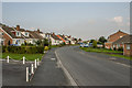
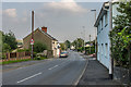
1
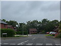
Looking along Brynceinion in the direction of the social hall
Image: © Basher Eyre
Taken: 26 Jun 2015
0.02 miles
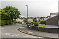
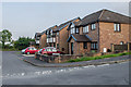
3
Waun Fawr
Housing in Waun Fawr. The one in the foreground, Elenydd, and the one in the left background, Blaencwmpadarn, are both shown on the 1886 6" map.
Image: © Ian Capper
Taken: 27 Jun 2015
0.05 miles
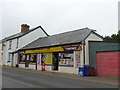
4
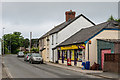
Hendre Stores
Local shop in Waun Fawr, adjacent to a short terrace of houses. Old maps show the far end of the terrace for many years to have housed a Sunday School.
Image: © Ian Capper
Taken: 27 Jun 2015
0.07 miles
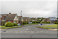
5
Rhoshendre
1960s/70s development in Waun Fawr.
Image: © Ian Capper
Taken: 26 Aug 2013
0.08 miles
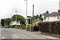
7
Heol Alun
Mid 1990s housing in Waun Fawr.
Image: © Ian Capper
Taken: 27 Jun 2015
0.08 miles
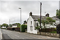
8
Waun Fawr
Housing in Waun Fawr. The one in the background, Blaencwmpadarn, is shown on the 1886 6" map.
Image: © Ian Capper
Taken: 27 Jun 2015
0.08 miles
9
Waun Fawr
Cottages in Waun Fawr, dating from when the village consisted of a few buildings along this former lane, before the wider development of the area from the 1960s onwards.
Image: © Ian Capper
Taken: 26 Aug 2013
0.08 miles
10
Llyshendre
Short (1990s?) cul-de-sac off Rhoshendre.
Image: © Ian Capper
Taken: 26 Aug 2013
0.11 miles