IMAGES TAKEN NEAR TO
Cwmerfyn, ABERYSTWYTH, SY23 3HB
Introduction
This page details the photographs taken nearby to SY23 3HB by members of the Geograph project.
The Geograph project started in 2005 with the aim of publishing, organising and preserving representative images for every square kilometre of Great Britain, Ireland and the Isle of Man.

There are currently over 7.5m images from over14,400 individuals and you can help contribute to the project by visiting https://www.geograph.org.uk
Image Map
Images are licensed for reuse under creativecommons.org/licenses/by-sa/2.0
Notes
- Clicking on the map will re-center to the selected point.
- The higher the marker number, the further away the image location is from the centre of the postcode.
Image Listing (3 Images Found)
Images are licensed for reuse under creativecommons.org/licenses/by-sa/2.0
Image
Details
Distance
1
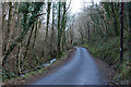
Road and stream leaving Cwm Erfyn
Exiting through a narrow part of the cwm, in woodland.
Image: © Nigel Brown
Taken: 22 Jan 2009
0.15 miles
2
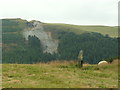
Cerrig-yr-Wyn
One of the two standing stones called 'Cerrig-yr-Wyn', each about three ft high and about 200yds apart. Looking SW. The scar on the hillside opposite is the old Darren metal mine (in SN6782), which was originally worked in the mid 16th Cent. There is also the remains of a hill fort on top of the hill.
Image: © Nigel Callaghan
Taken: 11 Aug 2005
0.23 miles
3
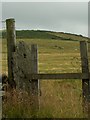
Gatepost and standing stone
Old stone gatepost and one of the two standing stones (in the middle of the field) that make up 'Cerrig-yr-Wyn'. Looking S.
Image: © Nigel Callaghan
Taken: 11 Aug 2005
0.23 miles