IMAGES TAKEN NEAR TO
Fifth Avenue, ABERYSTWYTH, SY23 1QT
Introduction
This page details the photographs taken nearby to Fifth Avenue, SY23 1QT by members of the Geograph project.
The Geograph project started in 2005 with the aim of publishing, organising and preserving representative images for every square kilometre of Great Britain, Ireland and the Isle of Man.

There are currently over 7.5m images from over14,400 individuals and you can help contribute to the project by visiting https://www.geograph.org.uk
Image Map
Images are licensed for reuse under creativecommons.org/licenses/by-sa/2.0
Notes
- Clicking on the map will re-center to the selected point.
- The higher the marker number, the further away the image location is from the centre of the postcode.
Image Listing (60 Images Found)
Images are licensed for reuse under creativecommons.org/licenses/by-sa/2.0
Image
Details
Distance
1
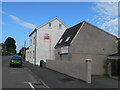
Footpath, Penparcau
Allotments on the other side of the hedge
Image: © John Lord
Taken: 10 Aug 2009
0.04 miles
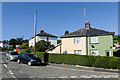
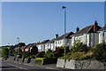
2
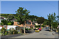
Fifth Avenue
1930s(?) housing below Penparcau Road, with the streets in the estate being imaginatively named First, Second, Third, Fourth and Fifth Avenue.
Image: © Ian Capper
Taken: 25 Aug 2013
0.05 miles
3
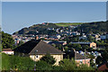
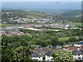
Aberystwyth rooftops
The rooftops of Aberystwyth, seen from Plas Helyg, off Penparcau Road. In the middle right of the photo is the new Vale of Rheidol Railway engine shed and in the far distance is Constitution Hill.
Image: © Ian Capper
Taken: 25 Aug 2013
0.05 miles
4
Caeffynnon and Beyond
The view west from the path to Pen Dinas includes Caeffynnon in the foreground and Llanbabarn Fawr and rolling countryside beyond.
Image: © Anne Burgess
Taken: 26 Jun 2015
0.07 miles
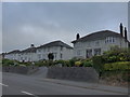
5
Second Avenue
1930s(?) housing below Penparcau Road, with the streets in the estate being imaginatively named First, Second, Third, Fourth and Fifth Avenue.
Image: © Ian Capper
Taken: 25 Aug 2013
0.09 miles
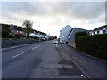
7
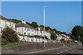
Penparcau Road
1930s housing on Penparcau Road.
Image: © Ian Capper
Taken: 25 Aug 2013
0.10 miles
8
Penparcau Road
1930s housing on Penparcau Road.
Image: © Ian Capper
Taken: 25 Aug 2013
0.10 miles
9
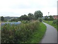
Penparcau Road, Aberystwyth
The A487 road from Aberystwyth to destinations south.
Image: © John Lucas
Taken: 27 Apr 2016
0.11 miles