IMAGES TAKEN NEAR TO
Pen Sarn Wen, LLANYMYNECH, SY22 6NU
Introduction
This page details the photographs taken nearby to Pen Sarn Wen, SY22 6NU by members of the Geograph project.
The Geograph project started in 2005 with the aim of publishing, organising and preserving representative images for every square kilometre of Great Britain, Ireland and the Isle of Man.

There are currently over 7.5m images from over14,400 individuals and you can help contribute to the project by visiting https://www.geograph.org.uk
Image Map
Images are licensed for reuse under creativecommons.org/licenses/by-sa/2.0
Notes
- Clicking on the map will re-center to the selected point.
- The higher the marker number, the further away the image location is from the centre of the postcode.
Image Listing (5 Images Found)
Images are licensed for reuse under creativecommons.org/licenses/by-sa/2.0
Image
Details
Distance
1
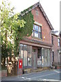
Abandoned Shop.
Shame to see an attractive building falling into disrepair.
Image: © Hefin Richards
Taken: 10 Sep 2006
0.15 miles
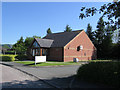
2
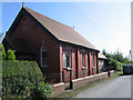
Llandrinio Methodist church
Llandrinio Methodist is situated some way from the village it serves.
Image: © John Firth
Taken: 24 May 2009
0.17 miles
3
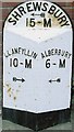
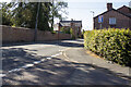
Old Milepost by the B4393, Sarn-wen, Llandrinio Parish
Turner Arrow Casting by the B4393, in parish of Llandrinio (Powys District), South of Four Crosses, against brick wall of bus shelter, West side of road, opposite Hendre Lane.
Inscription reads:- : LLANFYLLIN / 10-M / {arrow}: : SHREWSBURY / {arrow} / 15-M : : ALBERBURY / 6-M / {arrow} :
Surveyed
Milestone Society National ID: MOT_LFSA10
Image: © Milestone Society
Taken: Unknown
0.19 miles