IMAGES TAKEN NEAR TO
MEIFOD, SY22 6DL
Introduction
This page details the photographs taken nearby to SY22 6DL by members of the Geograph project.
The Geograph project started in 2005 with the aim of publishing, organising and preserving representative images for every square kilometre of Great Britain, Ireland and the Isle of Man.

There are currently over 7.5m images from over14,400 individuals and you can help contribute to the project by visiting https://www.geograph.org.uk
Image Map
Images are licensed for reuse under creativecommons.org/licenses/by-sa/2.0
Notes
- Clicking on the map will re-center to the selected point.
- The higher the marker number, the further away the image location is from the centre of the postcode.
Image Listing (4 Images Found)
Images are licensed for reuse under creativecommons.org/licenses/by-sa/2.0
Image
Details
Distance
1
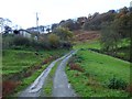
Ywen
This house nestles below Coed Gelli on Cefn Dreiniog.
Image: © Penny Mayes
Taken: 2 Nov 2007
0.01 miles
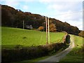
2
Coed Gelli
From the road to Gelli Farm. This is the southern end of the wood which covers Cefn Dreiniog. There are some farm buildings on the left.
Image: © Penny Mayes
Taken: 2 Nov 2007
0.07 miles
3

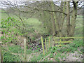
Pond by Eithar Bach brook
This pond looks man-made and doesn't appear to be mapped. The forestry plantation on the right seems to be called Bron Fedw (which I thought had something to do with birch trees) and covers a steep escarpment. Celyn Farm, in the centre of the image, is in the next square. Taken from the road to Gelli Farm.
Image: © Penny Mayes
Taken: 2 Nov 2007
0.22 miles