IMAGES TAKEN NEAR TO
Cwm Golau, Cyfronydd, WELSHPOOL, SY21 9EZ
Introduction
This page details the photographs taken nearby to SY21 9EZ by members of the Geograph project.
The Geograph project started in 2005 with the aim of publishing, organising and preserving representative images for every square kilometre of Great Britain, Ireland and the Isle of Man.

There are currently over 7.5m images from over14,400 individuals and you can help contribute to the project by visiting https://www.geograph.org.uk
Image Map
Images are licensed for reuse under creativecommons.org/licenses/by-sa/2.0
Notes
- Clicking on the map will re-center to the selected point.
- The higher the marker number, the further away the image location is from the centre of the postcode.
Image Listing (6 Images Found)
Images are licensed for reuse under creativecommons.org/licenses/by-sa/2.0
Image
Details
Distance
1
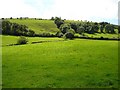
Pasture near Brynhyfryd
A brook runs across between the fields, marked by the trees on the left and line of bushes. The ridge follows the 240 metre contour.
Image: © Penny Mayes
Taken: 12 Aug 2007
0.14 miles
2
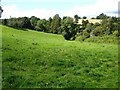
Pasture near Cwm Golau
Field west of Image The Cwm lies within the band of trees.
Image: © Penny Mayes
Taken: 12 Aug 2007
0.20 miles
3

Pasture near Cwm Golau
Between Image and the Cwm.
Image: © Penny Mayes
Taken: 12 Aug 2007
0.20 miles
4
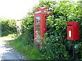
Cwm Golau call box
With post box alongside. This rural phone box is very difficult to get into in the summer as the hedge blocks the door.
Image: © Penny Mayes
Taken: 12 Aug 2007
0.23 miles
5
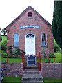
Cwmgolau Presbyterian Church
Occupying a tiny plot on the south side of the B4385 Llanfair road near Hen Defarn.
Image: © Penny Mayes
Taken: 12 Aug 2007
0.23 miles
6
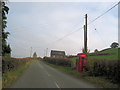
B4385 Cwm Golau
Phone box to right and chapel in the distance
Image: © John Firth
Taken: 29 Oct 2009
0.24 miles