IMAGES TAKEN NEAR TO
Castle Caereinion, WELSHPOOL, SY21 9AH
Introduction
This page details the photographs taken nearby to SY21 9AH by members of the Geograph project.
The Geograph project started in 2005 with the aim of publishing, organising and preserving representative images for every square kilometre of Great Britain, Ireland and the Isle of Man.

There are currently over 7.5m images from over14,400 individuals and you can help contribute to the project by visiting https://www.geograph.org.uk
Image Map
Images are licensed for reuse under creativecommons.org/licenses/by-sa/2.0
Notes
- Clicking on the map will re-center to the selected point.
- The higher the marker number, the further away the image location is from the centre of the postcode.
Image Listing (4 Images Found)
Images are licensed for reuse under creativecommons.org/licenses/by-sa/2.0
Image
Details
Distance
1
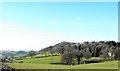
View NW from Coppice Lane
The building on the right is Sylfaen. Hen Gwm Farm stands on the top of the ridge and lies just beyond the NW corner of the square. The road just visible lower left is the main A458 Welshpool to Dolgellau.
Image: © Penny Mayes
Taken: 21 Feb 2009
0.09 miles
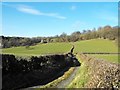
3
View from minor road
Main A458 visible in left middle
Image: © John Firth
Taken: 1 Jun 2009
0.18 miles
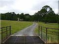
4
Track from Coppice Lane
This short track runs from Coppice Lane to the A458 main Dolgellau/Welshpool road. Useful if you've driven up from Castle Caereinion and want to turn left towards Dolgellau as the angle is difficult from the end of Coppice Lane. It looks as if the track continues alongside the hedge on the other side of the main road although it doesn't seem to be used much.
Image: © Penny Mayes
Taken: 21 Feb 2009
0.19 miles