IMAGES TAKEN NEAR TO
Brunant, Buttington, WELSHPOOL, SY21 8TF
Introduction
This page details the photographs taken nearby to SY21 8TF by members of the Geograph project.
The Geograph project started in 2005 with the aim of publishing, organising and preserving representative images for every square kilometre of Great Britain, Ireland and the Isle of Man.

There are currently over 7.5m images from over14,400 individuals and you can help contribute to the project by visiting https://www.geograph.org.uk
Image Map
Images are licensed for reuse under creativecommons.org/licenses/by-sa/2.0
Notes
- Clicking on the map will re-center to the selected point.
- The higher the marker number, the further away the image location is from the centre of the postcode.
Image Listing (3 Images Found)
Images are licensed for reuse under creativecommons.org/licenses/by-sa/2.0
Image
Details
Distance
1
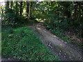
Footpath leading off Heldre Hill to Brunant
Good descent off the hill brings you down this lovely footpath
Image: © Andrew Shannon
Taken: 8 Sep 2021
0.03 miles
2
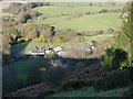
The settlement at Brunant
From high on Heldre Hill above the farms.
Image: © Richard Law
Taken: 11 Nov 2012
0.03 miles
3
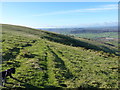
Heading across Heldre Hill
Much of this part of the hill is mapped as CROW Access Land, and this sheep-track avoids the need to lose a couple of hundred feet following the footpath down to Brunant and back up. Which is rather handy.
Image: © Richard Law
Taken: 11 Nov 2012
0.17 miles